Lipuntahuaca geodata
Lipuntahuaca (Puebla) is a populated place; located in Mexico in America/Mexico_City (GMT-6) time zone. With population of 1,484 people, there are 5814 cities with bigger population in this country. Compared to other cities in Mexico, 58.9% of cities are located further ↓South; 68.1% of cities are located further ←West and 69.1% of cities have higher elevation than Lipuntahuaca. Note1


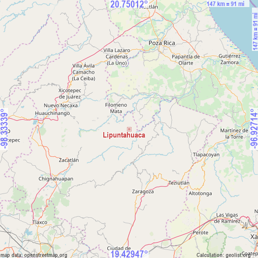
Lipuntahuaca GPS coordinates[2]
20° 5' 28.284" North, 97° 37' 48.936" West
| Map corner | latitude | longitude |
|---|---|---|
| Upper-left | 20.75012°, | -98.33339° |
| Center: | 20.09119°, | -97.63026° |
| Lower-right: | 19.42947°, | -96.92714° |
| Map W x H: | 146.8×146.8 km | = 91.2×91.2mi |
| max Lat: | 32.7° ⇑41.1% North |
| Lipuntahuaca: | 20.09119° |
| min Lat: | ⇓58.9% South 14.53588° |
| min Long | Lipuntahuaca | max Long |
| -117.105° | -97.63026° | -86.73105° |
| W 68.1%⇐ | ⇒31.9% E |
Elevation
Elevation of Lipuntahuaca is 465 m = 1526 ft, and this is 788.7 m = 2588 ft below average elevation for this country.
| Max E: |
3497 m = 11473 ft | 69.1% |
| Avg. | 1253.7 m = 4113 ft | |
| Lipuntahuaca | 465 m = 1526 ft | |
Min E: |
-1 m = -3 ft | 30.9% |
See also: Mexico elevation on elevation.city.
Geographical zone
Lipuntahuaca is located in North Torrid zone (between Equator and Tropic of Cancer). Distance of this Northern Tropic circle is 372 km =231.2 mi to North.| Distance of | km | miles | from Lipuntahuaca |
|---|---|---|---|
| North Pole | 7773.1 | 4830 | to North |
| Arctic Circle | 5167.2 | 3210.7 | to North |
| Tropic Cancer | 372 | 231.2 | to North |
| Equator | 2233.9 | 1388.1 | to South |


Nearby cities:
15 places around Lipuntahuaca: (largest is in red/bold)
• Acatzácatl
5.2 km =3.2 mi,  65°
65°
• Caxhuacán
3.9 km =2.4 mi,  141°
141°
• Chilocoyo del Carmen
2.9 km =1.8 mi,  244°
244°
• Cinco de Mayo
4.5 km =2.8 mi,  0°
0°
• Escatachuchut
4.1 km =2.5 mi,  190°
190°
• Francisco I. Madero
3.6 km =2.2 mi,  61°
61°
• Huehuetla
1.7 km =1.1 mi,  18°
18°
• Kuwik Chuchut
3.1 km =1.9 mi,  41°
41°
• Lacapan Camallagne
4.8 km =3 mi,  329°
329°
• Leacaman
1.6 km =1 mi,  301°
301°
• Ozelonacaxtla
5.2 km =3.2 mi,  161°
161°
• Pumacachocochuchut
3.3 km =2.1 mi, 327°
• Putaxcat
0.6 km =0.4 mi, 64°
• Vicente Guerrero
4.3 km =2.7 mi,  324°
324°
• Xonalpu
4.6 km =2.9 mi,  26°
26°
Sources, notices
• [Note1] Compared only with cities in Mexico existing in our database
• [Src1] Map data: © OpenStreetMap contributors (CC-BY-SA)
• [Src2] Other city data from geonames.org with taken over terms of usage.
• [Src3] Geographical zone / Annual Mean Temperature by Robert A. Rohde @ Wikipedia
