Buenos Aires el Apompo geodata
Buenos Aires el Apompo (Oaxaca) is a populated place; located in Mexico in America/Mexico_City (GMT-6) time zone. With population of 571 people, there are 14980 cities with bigger population in this country. Compared to other cities in Mexico, 77% of cities are located further ↑North; 80.9% of cities are located further ←West and 82.8% of cities have higher elevation than Buenos Aires el Apompo. Note1
Current local time in Buenos Aires el Apompo:
06:53 AM, WednesdayDifference from your time zone: hours


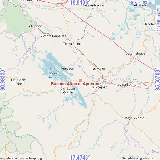
Buenos Aires el Apompo GPS coordinates[2]
18° 8' 37.428" North, 96° 17' 24.72" West
| Map corner | latitude | longitude |
|---|---|---|
| Upper-left | 18.8106°, | -96.99333° |
| Center: | 18.14373°, | -96.2902° |
| Lower-right: | 17.4743°, | -95.58708° |
| Map W x H: | 148.6×148.6 km | = 92.3×92.3mi |
| max Lat: | 32.7° ⇑77% North |
| Buenos Aires el Apompo: | 18.14373° |
| min Lat: | ⇓23% South 14.53588° |
| min Long | Buenos Aires el | max Long |
| -117.105° | -96.2902° | -86.73105° |
| W 80.9%⇐ | ⇒19.1% E |
Elevation
Elevation of Buenos Aires el Apompo is 62 m = 203 ft, and this is 1191.7 m = 3910 ft below average elevation for this country.
| Max E: |
3497 m = 11473 ft | 82.8% |
| Avg. | 1253.7 m = 4113 ft | |
| Buenos Aires el Apompo | 62 m = 203 ft | |
Min E: |
-1 m = -3 ft | 17.2% |
See also: Mexico elevation on elevation.city.
Geographical zone
Buenos Aires el Apompo is located in North Torrid zone (between Equator and Tropic of Cancer). Distance of this Northern Tropic circle is 588.5 km =365.7 mi to North.| Distance of | km | miles | from Buenos Aires el Apompo |
|---|---|---|---|
| North Pole | 7989.7 | 4964.6 | to North |
| Arctic Circle | 5383.8 | 3345.3 | to North |
| Tropic Cancer | 588.5 | 365.7 | to North |
| Equator | 2017.4 | 1253.6 | to South |


Nearby cities:
15 places around Buenos Aires el Apompo: (largest is in red/bold)
• Arroyo Chical (Nuevo Arroyo Chicali)
9.4 km =5.8 mi,  328°
328°
• Cerro Tepezcuintle
5.5 km =3.4 mi,  273°
273°
• Corral de Piedra
11.4 km =7.1 mi,  351°
351°
• El Camarón
10 km =6.2 mi,  112°
112°
• El Capulín (La Nueva Pochota)
9.6 km =6 mi,  7°
7°
• El Porvenir
7.9 km =4.9 mi,  80°
80°
• Las Margaritas
12.4 km =7.7 mi,  2°
2°
• Macín Chico
8.6 km =5.3 mi,  166°
166°
• Mazín Grande
3.7 km =2.3 mi,  213°
213°
• Nuevo Pescadito de Abajo
12.4 km =7.7 mi, 327°
• Nuevo Pescadito de Abajo Dos
11.8 km =7.3 mi, 271°
• Paso Rincón
13.6 km =8.5 mi,  359°
359°
• San Isidro
10.6 km =6.6 mi,  85°
85°
• San José Lagunas
10.5 km =6.5 mi,  251°
251°
• Soledad Macín Chico
12 km =7.5 mi,  141°
141°
Sources, notices
• [Note1] Compared only with cities in Mexico existing in our database
• [Src1] Map data: © OpenStreetMap contributors (CC-BY-SA)
• [Src2] Other city data from geonames.org with taken over terms of usage.
• [Src3] Geographical zone / Annual Mean Temperature by Robert A. Rohde @ Wikipedia
