Buenavista geodata
Buenavista (Puebla) is a populated place; located in Mexico in America/Mexico_City (GMT-6) time zone. With population of 1,028 people, there are 8476 cities with bigger population in this country. Compared to other cities in Mexico, 59.7% of cities are located further ↑North; 73.9% of cities are located further ←West and 77.9% of cities have lower elevation than Buenavista. Note1


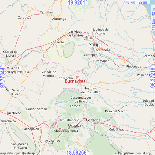
Buenavista GPS coordinates[2]
19° 15' 27.612" North, 97° 4' 31.116" West
| Map corner | latitude | longitude |
|---|---|---|
| Upper-left | 19.9201°, | -97.77844° |
| Center: | 19.25767°, | -97.07531° |
| Lower-right: | 18.59256°, | -96.37219° |
| Map W x H: | 147.6×147.6 km | = 91.7×91.7mi |
| max Lat: | 32.7° ⇑59.7% North |
| Buenavista: | 19.25767° |
| min Lat: | ⇓40.3% South 14.53588° |
| min Long | Buenavista | max Long |
| -117.105° | -97.07531° | -86.73105° |
| W 73.9%⇐ | ⇒26.1% E |
Elevation
Elevation of Buenavista is 2086 m = 6844 ft, and this is 832.3 m = 2731 ft above average elevation for this country.
| Max E: |
3497 m = 11473 ft | 22.1% |
| Buenavista | 2086 m 6844 ft | |
| Avg. | 1253.7 m = 4113 ft | |
Min E: |
-1 m = -3 ft | 77.9% |
See also: Mexico elevation on elevation.city.
Geographical zone
Buenavista is located in North Torrid zone (between Equator and Tropic of Cancer). Distance of this Northern Tropic circle is 464.7 km =288.8 mi to North.| Distance of | km | miles | from Buenavista |
|---|---|---|---|
| North Pole | 7865.8 | 4887.6 | to North |
| Arctic Circle | 5259.9 | 3268.3 | to North |
| Tropic Cancer | 464.7 | 288.8 | to North |
| Equator | 2141.3 | 1330.5 | to South |


Nearby cities:
15 places around Buenavista: (largest is in red/bold)
• Ahuacapan
6.9 km =4.3 mi,  290°
290°
• Chichiquila
6.4 km =4 mi,  172°
172°
• Cinco de Mayo
1.7 km =1.1 mi,  179°
179°
• Colonia la Concepción
1.8 km =1.1 mi,  236°
236°
• El Rosario
3.8 km =2.4 mi, 180°
• El Triunfo
5 km =3.1 mi,  125°
125°
• Huaxcaleca
2.6 km =1.6 mi, 183°
• Ojo de Agua
7.1 km =4.4 mi,  215°
215°
• San Isidro Reynosa
0.6 km =0.4 mi,  85°
85°
• Tlamanca
5.7 km =3.5 mi,  315°
315°
• Tlamoloaxtla
3.5 km =2.2 mi,  346°
346°
• Tozihuic
2.4 km =1.5 mi,  252°
252°
• Villa Hermosa (San José)
0.5 km =0.3 mi, 287°
• Xochimilco
6.4 km =4 mi,  208°
208°
• Xopanapa
7.1 km =4.4 mi, 210°
Sources, notices
• [Note1] Compared only with cities in Mexico existing in our database
• [Src1] Map data: © OpenStreetMap contributors (CC-BY-SA)
• [Src2] Other city data from geonames.org with taken over terms of usage.
• [Src3] Geographical zone / Annual Mean Temperature by Robert A. Rohde @ Wikipedia
