Huaxcaleca geodata
Huaxcaleca (Puebla) is a populated place; located in Mexico in America/Mexico_City (GMT-6) time zone. With population of 2,081 people, there are 4197 cities with bigger population in this country. Compared to other cities in Mexico, 60.2% of cities are located further ↑North; 73.9% of cities are located further ←West and 78.7% of cities have lower elevation than Huaxcaleca. Note1


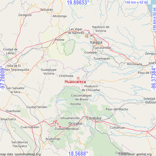
Huaxcaleca GPS coordinates[2]
19° 14' 2.436" North, 97° 4' 37.056" West
| Map corner | latitude | longitude |
|---|---|---|
| Upper-left | 19.89653°, | -97.78009° |
| Center: | 19.23401°, | -97.07696° |
| Lower-right: | 18.5688°, | -96.37384° |
| Map W x H: | 147.6×147.6 km | = 91.7×91.7mi |
| max Lat: | 32.7° ⇑60.2% North |
| Huaxcaleca: | 19.23401° |
| min Lat: | ⇓39.8% South 14.53588° |
| min Long | Huaxcaleca | max Long |
| -117.105° | -97.07696° | -86.73105° |
| W 73.9%⇐ | ⇒26.1% E |
Elevation
Elevation of Huaxcaleca is 2105 m = 6906 ft, and this is 851.3 m = 2793 ft above average elevation for this country.
| Max E: |
3497 m = 11473 ft | 21.3% |
| Huaxcaleca | 2105 m 6906 ft | |
| Avg. | 1253.7 m = 4113 ft | |
Min E: |
-1 m = -3 ft | 78.7% |
See also: Mexico elevation on elevation.city.
Geographical zone
Huaxcaleca is located in North Torrid zone (between Equator and Tropic of Cancer). Distance of this Northern Tropic circle is 467.3 km =290.4 mi to North.| Distance of | km | miles | from Huaxcaleca |
|---|---|---|---|
| North Pole | 7868.4 | 4889.2 | to North |
| Arctic Circle | 5262.6 | 3270 | to North |
| Tropic Cancer | 467.3 | 290.4 | to North |
| Equator | 2138.6 | 1328.9 | to South |


Nearby cities:
15 places around Huaxcaleca: (largest is in red/bold)
• Atlaxco
5.4 km =3.4 mi,  194°
194°
• Buenavista
2.6 km =1.6 mi,  3°
3°
• Chichiquila
3.8 km =2.4 mi,  164°
164°
• Cinco de Mayo
1 km =0.6 mi,  10°
10°
• Colonia la Concepción
2.1 km =1.3 mi,  319°
319°
• Dos Ríos
5.6 km =3.5 mi,  178°
178°
• El Rosario
1.1 km =0.7 mi,  174°
174°
• El Triunfo
4.2 km =2.6 mi,  93°
93°
• Ojo de Agua
5 km =3.1 mi,  231°
231°
• San Isidro Reynosa
2.8 km =1.7 mi,  16°
16°
• Tlamoloaxtla
6.1 km =3.8 mi,  353°
353°
• Tozihuic
2.9 km =1.8 mi,  312°
312°
• Villa Hermosa (San José)
2.8 km =1.7 mi, 352°
• Xochimilco
4.2 km =2.6 mi,  223°
223°
• Xopanapa
4.9 km =3 mi, 224°
Sources, notices
• [Note1] Compared only with cities in Mexico existing in our database
• [Src1] Map data: © OpenStreetMap contributors (CC-BY-SA)
• [Src2] Other city data from geonames.org with taken over terms of usage.
• [Src3] Geographical zone / Annual Mean Temperature by Robert A. Rohde @ Wikipedia
