Loma de Guadalupe geodata
Loma de Guadalupe (State of Mexico) is a populated place; located in Mexico in America/Mexico_City (GMT-6) time zone. With population of 598 people, there are 14373 cities with bigger population in this country. Compared to other cities in Mexico, 53.8% of cities are located further ↑North; 64% of cities are located further →East and 96.3% of cities have lower elevation than Loma de Guadalupe. Note1


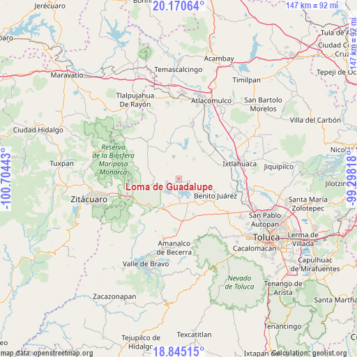
Loma de Guadalupe GPS coordinates[2]
19° 30' 33.3" North, 100° 0' 4.68" West
| Map corner | latitude | longitude |
|---|---|---|
| Upper-left | 20.17064°, | -100.70443° |
| Center: | 19.50925°, | -100.0013° |
| Lower-right: | 18.84515°, | -99.29818° |
| Map W x H: | 147.4×147.4 km | = 91.6×91.6mi |
| max Lat: | 32.7° ⇑53.8% North |
| Loma de Guadalupe: | 19.50925° |
| min Lat: | ⇓46.2% South 14.53588° |
| min Long | Loma de Guadalu | max Long |
| -117.105° | -100.0013° | -86.73105° |
| W 36%⇐ | ⇒64% E |
Elevation
Elevation of Loma de Guadalupe is 2641 m = 8665 ft, and this is 1387.3 m = 4552 ft above average elevation for this country.
| Max E: |
3497 m = 11473 ft | 3.7% |
| Loma de Guadalupe | 2641 m 8665 ft | |
| Avg. | 1253.7 m = 4113 ft | |
Min E: |
-1 m = -3 ft | 96.3% |
See also: Mexico elevation on elevation.city.
Geographical zone
Loma de Guadalupe is located in North Torrid zone (between Equator and Tropic of Cancer). Distance of this Northern Tropic circle is 436.7 km =271.4 mi to North.| Distance of | km | miles | from Loma de Guadalupe |
|---|---|---|---|
| North Pole | 7837.8 | 4870.2 | to North |
| Arctic Circle | 5231.9 | 3251 | to North |
| Tropic Cancer | 436.7 | 271.4 | to North |
| Equator | 2169.2 | 1347.9 | to South |


Nearby cities:
15 places around Loma de Guadalupe: (largest is in red/bold)
• Agua Grande
3.4 km =2.1 mi,  320°
320°
• Agua Zarca
4.6 km =2.9 mi,  334°
334°
• Barrio de Puentecillas
3.4 km =2.1 mi,  30°
30°
• Barrio de San Isidro
4.7 km =2.9 mi,  73°
73°
• Barrio de San Miguel
4.9 km =3 mi,  86°
86°
• Barrio el Centenario
1.2 km =0.7 mi, 30°
• Cerrillo Grande
4.8 km =3 mi,  286°
286°
• Cuadrilla Vieja
1.5 km =0.9 mi,  78°
78°
• La Alameda
2.5 km =1.6 mi, 88°
• Los Cedros Suchitepec
3.6 km =2.2 mi,  269°
269°
• Nuevo Bosque
3.8 km =2.4 mi,  246°
246°
• Ramejé
2.3 km =1.4 mi, 325°
• San Diego del Cerrito
0.6 km =0.4 mi,  256°
256°
• San Marcos de la Loma
4.4 km =2.7 mi,  101°
101°
• San Roque
5.3 km =3.3 mi,  127°
127°
Sources, notices
• [Note1] Compared only with cities in Mexico existing in our database
• [Src1] Map data: © OpenStreetMap contributors (CC-BY-SA)
• [Src2] Other city data from geonames.org with taken over terms of usage.
• [Src3] Geographical zone / Annual Mean Temperature by Robert A. Rohde @ Wikipedia
