Lagunillas geodata
Lagunillas (Michoacán) is a seat of a second-order administrative division; located in Mexico in America/Mexico_City (GMT-6) time zone. With population of 2,494 people, there are 3545 cities with bigger population in this country. Compared to other cities in Mexico, 52.8% of cities are located further ↑North; 76.6% of cities are located further →East and 78.9% of cities have lower elevation than Lagunillas. Note1


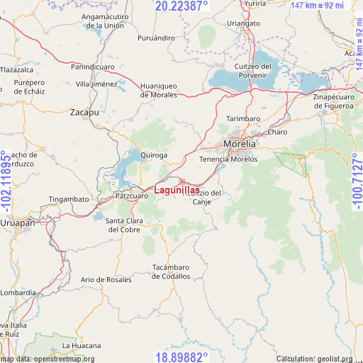
Lagunillas GPS coordinates[2]
19° 33' 45.756" North, 101° 24' 56.952" West
| Map corner | latitude | longitude |
|---|---|---|
| Upper-left | 20.22387°, | -102.11895° |
| Center: | 19.56271°, | -101.41582° |
| Lower-right: | 18.89882°, | -100.7127° |
| Map W x H: | 147.3×147.3 km | = 91.5×91.5mi |
| max Lat: | 32.7° ⇑52.8% North |
| Lagunillas: | 19.56271° |
| min Lat: | ⇓47.2% South 14.53588° |
| min Long | Lagunillas | max Long |
| -117.105° | -101.41582° | -86.73105° |
| W 23.4%⇐ | ⇒76.6% E |
Elevation
Elevation of Lagunillas is 2110 m = 6923 ft, and this is 856.3 m = 2809 ft above average elevation for this country.
| Max E: |
3497 m = 11473 ft | 21.1% |
| Lagunillas | 2110 m 6923 ft | |
| Avg. | 1253.7 m = 4113 ft | |
Min E: |
-1 m = -3 ft | 78.9% |
See also: Mexico elevation on elevation.city.
Geographical zone
Lagunillas is located in North Torrid zone (between Equator and Tropic of Cancer). Distance of this Northern Tropic circle is 430.7 km =267.6 mi to North.| Distance of | km | miles | from Lagunillas |
|---|---|---|---|
| North Pole | 7831.9 | 4866.5 | to North |
| Arctic Circle | 5226 | 3247.3 | to North |
| Tropic Cancer | 430.7 | 267.6 | to North |
| Equator | 2175.2 | 1351.6 | to South |


Nearby cities:
15 places around Lagunillas: (largest is in red/bold)
• Acuítzio del Canje
11.4 km =7.1 mi,  130°
130°
• Chihuerio
9 km =5.6 mi,  165°
165°
• El Correo
7.5 km =4.7 mi,  357°
357°
• El Pedregal
6.7 km =4.2 mi,  211°
211°
• El Sobrado
7.3 km =4.5 mi,  222°
222°
• Fontezuelas
4.5 km =2.8 mi,  302°
302°
• Huiramba
2.9 km =1.8 mi,  229°
229°
• Iratzio
9.3 km =5.8 mi,  2°
2°
• La Caja
3.2 km =2 mi,  325°
325°
• Las Tablas
7.4 km =4.6 mi,  201°
201°
• San Andrés Coapa
8 km =5 mi,  154°
154°
• San José Coapa
3.2 km =2 mi,  99°
99°
• San Rafael Coapa
6.9 km =4.3 mi, 126°
• Tirípetio
7.4 km =4.6 mi, 101°
• Tupátaro
10.4 km =6.5 mi, 230°
Sources, notices
• [Note1] Compared only with cities in Mexico existing in our database
• [Src1] Map data: © OpenStreetMap contributors (CC-BY-SA)
• [Src2] Other city data from geonames.org with taken over terms of usage.
• [Src3] Geographical zone / Annual Mean Temperature by Robert A. Rohde @ Wikipedia
