Nuevo Renacimiento 2000 geodata
Nuevo Renacimiento 2000 (Veracruz) is a populated place; located in Mexico in America/Mexico_City (GMT-6) time zone. With population of 991 people, there are 8788 cities with bigger population in this country. Compared to other cities in Mexico, 66.4% of cities are located further ↓South; 74% of cities are located further ←West and 86.7% of cities have higher elevation than Nuevo Renacimiento 2000. Note1
Current local time in Nuevo Renacimiento 2000:
03:40 AM, WednesdayDifference from your time zone: hours


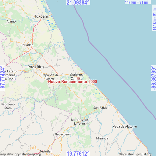
Nuevo Renacimiento 2000 GPS coordinates[2]
20° 26' 11.004" North, 97° 4' 15.996" West
| Map corner | latitude | longitude |
|---|---|---|
| Upper-left | 21.09384°, | -97.77424° |
| Center: | 20.43639°, | -97.07111° |
| Lower-right: | 19.77612°, | -96.36799° |
| Map W x H: | 146.5×146.5 km | = 91×91mi |
| max Lat: | 32.7° ⇑33.6% North |
| Nuevo Renacimiento 2000: | 20.43639° |
| min Lat: | ⇓66.4% South 14.53588° |
| min Long | Nuevo Renacimie | max Long |
| -117.105° | -97.07111° | -86.73105° |
| W 74%⇐ | ⇒26% E |
Elevation
Elevation of Nuevo Renacimiento 2000 is 35 m = 115 ft, and this is 1218.7 m = 3998 ft below average elevation for this country.
| Max E: |
3497 m = 11473 ft | 86.7% |
| Avg. | 1253.7 m = 4113 ft | |
| Nuevo Renacimiento 2000 | 35 m = 115 ft | |
Min E: |
-1 m = -3 ft | 13.3% |
See also: Mexico elevation on elevation.city.
Geographical zone
Nuevo Renacimiento 2000 is located in North Torrid zone (between Equator and Tropic of Cancer). Distance of this Northern Tropic circle is 333.6 km =207.3 mi to North.| Distance of | km | miles | from Nuevo Renacimiento 2000 |
|---|---|---|---|
| North Pole | 7734.7 | 4806.1 | to North |
| Arctic Circle | 5128.9 | 3186.9 | to North |
| Tropic Cancer | 333.6 | 207.3 | to North |
| Equator | 2272.3 | 1411.9 | to South |


Nearby cities:
15 places around Nuevo Renacimiento 2000: (largest is in red/bold)
• Anclón y Arenal
4.7 km =2.9 mi,  268°
268°
• Carrillo Puerto
11.4 km =7.1 mi,  260°
260°
• Cañada Rica
13.7 km =8.5 mi,  192°
192°
• Cruz de los Esteros
5.2 km =3.2 mi,  85°
85°
• Emiliano Zapata
13.4 km =8.3 mi,  242°
242°
• Gutiérrez Zamora
2.4 km =1.5 mi,  320°
320°
• Hermenegildo Galeana
9.3 km =5.8 mi,  289°
289°
• Hueytepec
13.1 km =8.1 mi,  159°
159°
• Ignacio M. Altamirano (Plan de Altamirano)
8.4 km =5.2 mi,  229°
229°
• Lomas de Arena
9.8 km =6.1 mi,  252°
252°
• Montana de Zaragoza
14.6 km =9.1 mi, 228°
• Paso del Progreso
13.3 km =8.3 mi,  211°
211°
• Rafael Valenzuela
6.8 km =4.2 mi, 239°
• San Pablo
12.9 km =8 mi,  283°
283°
• Tecolutla
7.8 km =4.8 mi,  50°
50°
Sources, notices
• [Note1] Compared only with cities in Mexico existing in our database
• [Src1] Map data: © OpenStreetMap contributors (CC-BY-SA)
• [Src2] Other city data from geonames.org with taken over terms of usage.
• [Src3] Geographical zone / Annual Mean Temperature by Robert A. Rohde @ Wikipedia
