Tecolutla geodata
Tecolutla (Veracruz) is a seat of a second-order administrative division; located in Mexico in America/Mexico_City (GMT-6) time zone. With population of 4,591 people, there are 2004 cities with bigger population in this country. Compared to other cities in Mexico, 67.4% of cities are located further ↓South; 74.7% of cities are located further ←West and 98.1% of cities have higher elevation than Tecolutla. Note1


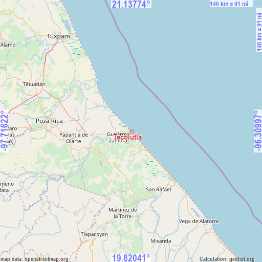
Tecolutla GPS coordinates[2]
20° 28' 49.764" North, 97° 0' 47.124" West
| Map corner | latitude | longitude |
|---|---|---|
| Upper-left | 21.13774°, | -97.71622° |
| Center: | 20.48049°, | -97.01309° |
| Lower-right: | 19.82041°, | -96.30997° |
| Map W x H: | 146.5×146.5 km | = 91×91mi |
| max Lat: | 32.7° ⇑32.6% North |
| Tecolutla: | 20.48049° |
| min Lat: | ⇓67.4% South 14.53588° |
| min Long | Tecolutla | max Long |
| -117.105° | -97.01309° | -86.73105° |
| W 74.7%⇐ | ⇒25.3% E |
Elevation
Elevation of Tecolutla is 8 m = 26 ft, and this is 1245.7 m = 4087 ft below average elevation for this country.
| Max E: |
3497 m = 11473 ft | 98.1% |
| Avg. | 1253.7 m = 4113 ft | |
| Tecolutla | 8 m = 26 ft | |
Min E: |
-1 m = -3 ft | 1.9% |
See also: Mexico elevation on elevation.city.
Geographical zone
Tecolutla is located in North Torrid zone (between Equator and Tropic of Cancer). Distance of this Northern Tropic circle is 328.7 km =204.2 mi to North.| Distance of | km | miles | from Tecolutla |
|---|---|---|---|
| North Pole | 7729.8 | 4803.1 | to North |
| Arctic Circle | 5124 | 3183.9 | to North |
| Tropic Cancer | 328.7 | 204.2 | to North |
| Equator | 2277.2 | 1415 | to South |


Nearby cities:
15 places around Tecolutla: (largest is in red/bold)
• Anclón y Arenal
11.9 km =7.4 mi,  244°
244°
• Boca de Lima
15.3 km =9.5 mi,  303°
303°
• Carrillo Puerto
18.6 km =11.6 mi,  248°
248°
• Cruz de los Esteros
4.6 km =2.9 mi,  190°
190°
• El Cedro
20.3 km =12.6 mi,  269°
269°
• Gutiérrez Zamora
8.2 km =5.1 mi, 248°
• Hermenegildo Galeana
14.9 km =9.3 mi,  263°
263°
• Hueytepec
17.2 km =10.7 mi,  184°
184°
• Ignacio M. Altamirano (Plan de Altamirano)
16.2 km =10.1 mi,  230°
230°
• La Guadalupe
15.4 km =9.6 mi,  140°
140°
• Lomas de Arena
17.3 km =10.7 mi, 243°
• Nuevo Renacimiento 2000
7.8 km =4.8 mi, 230°
• Rafael Valenzuela
14.6 km =9.1 mi, 235°
• Ricardo Flores Magón
17.6 km =10.9 mi, 140°
• San Pablo
18.7 km =11.6 mi, 263°
Sources, notices
• [Note1] Compared only with cities in Mexico existing in our database
• [Src1] Map data: © OpenStreetMap contributors (CC-BY-SA)
• [Src2] Other city data from geonames.org with taken over terms of usage.
• [Src3] Geographical zone / Annual Mean Temperature by Robert A. Rohde @ Wikipedia
