Álvaro Obregón geodata
Álvaro Obregón (Chiapas) is a populated place; located in Mexico in America/Mexico_City (GMT-6) time zone. With population of 983 people, there are 8847 cities with bigger population in this country. Compared to other cities in Mexico, 83.7% of cities are located further ↑North; 91.5% of cities are located further ←West and 70.7% of cities have higher elevation than Álvaro Obregón. Note1


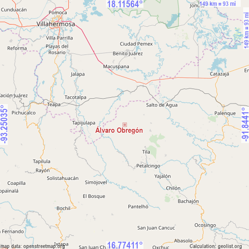
Álvaro Obregón GPS coordinates[2]
17° 26' 45.996" North, 92° 32' 49.992" West
| Map corner | latitude | longitude |
|---|---|---|
| Upper-left | 18.11564°, | -93.25035° |
| Center: | 17.44611°, | -92.54722° |
| Lower-right: | 16.77411°, | -91.8441° |
| Map W x H: | 149.2×149.2 km | = 92.7×92.7mi |
| max Lat: | 32.7° ⇑83.7% North |
| Álvaro Obregón: | 17.44611° |
| min Lat: | ⇓16.3% South 14.53588° |
| min Long | Álvaro Obregó | max Long |
| -117.105° | -92.54722° | -86.73105° |
| W 91.5%⇐ | ⇒8.5% E |
Elevation
Elevation of Álvaro Obregón is 385 m = 1263 ft, and this is 868.7 m = 2850 ft below average elevation for this country.
| Max E: |
3497 m = 11473 ft | 70.7% |
| Avg. | 1253.7 m = 4113 ft | |
| Álvaro Obregón | 385 m = 1263 ft | |
Min E: |
-1 m = -3 ft | 29.3% |
See also: Mexico elevation on elevation.city.
Geographical zone
Álvaro Obregón is located in North Torrid zone (between Equator and Tropic of Cancer). Distance of this Northern Tropic circle is 666.1 km =413.9 mi to North.| Distance of | km | miles | from Álvaro Obregón |
|---|---|---|---|
| North Pole | 8067.2 | 5012.7 | to North |
| Arctic Circle | 5461.3 | 3393.5 | to North |
| Tropic Cancer | 666.1 | 413.9 | to North |
| Equator | 1939.8 | 1205.3 | to South |


Nearby cities:
15 places around Álvaro Obregón: (largest is in red/bold)
• Agua Blanca
9.1 km =5.7 mi,  299°
299°
• Cerro Misopa
12.4 km =7.7 mi,  13°
13°
• Chulum Cárdenas
7.4 km =4.6 mi,  202°
202°
• Chulum Juárez
12.8 km =8 mi,  173°
173°
• El Bebedero
12 km =7.5 mi,  243°
243°
• El Crucero
12.4 km =7.7 mi,  133°
133°
• Guayal
11.4 km =7.1 mi,  330°
330°
• Jesús Carranza
12 km =7.5 mi,  251°
251°
• Libertad Jolnishtie 2da. Sección
4.4 km =2.7 mi,  115°
115°
• Ostelucum
11.6 km =7.2 mi,  208°
208°
• Paso Chinal
6.7 km =4.2 mi,  33°
33°
• Tza'Quil
9.2 km =5.7 mi, 123°
• Unión Hidalgo (El Chorro)
11.1 km =6.9 mi, 211°
• Unión Juárez
10.9 km =6.8 mi,  232°
232°
• Usipa
13.1 km =8.1 mi,  62°
62°
Sources, notices
• [Note1] Compared only with cities in Mexico existing in our database
• [Src1] Map data: © OpenStreetMap contributors (CC-BY-SA)
• [Src2] Other city data from geonames.org with taken over terms of usage.
• [Src3] Geographical zone / Annual Mean Temperature by Robert A. Rohde @ Wikipedia
