Guayal geodata
Guayal (Tabasco) is a populated place; located in Mexico in America/Mexico_City (GMT-6) time zone. With population of 954 people, there are 9131 cities with bigger population in this country. Compared to other cities in Mexico, 82.8% of cities are located further ↑North; 91.1% of cities are located further ←West and 84.3% of cities have higher elevation than Guayal. Note1


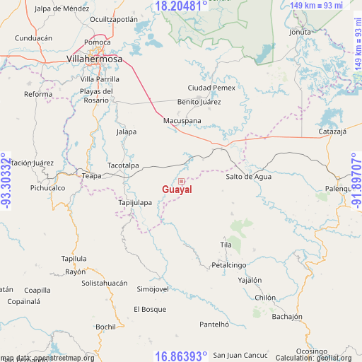
Guayal GPS coordinates[2]
17° 32' 8.196" North, 92° 36' 0.684" West
| Map corner | latitude | longitude |
|---|---|---|
| Upper-left | 18.20481°, | -93.30332° |
| Center: | 17.53561°, | -92.60019° |
| Lower-right: | 16.86393°, | -91.89707° |
| Map W x H: | 149.1×149.1 km | = 92.6×92.6mi |
| max Lat: | 32.7° ⇑82.8% North |
| Guayal: | 17.53561° |
| min Lat: | ⇓17.2% South 14.53588° |
| min Long | Guayal | max Long |
| -117.105° | -92.60019° | -86.73105° |
| W 91.1%⇐ | ⇒8.9% E |
Elevation
Elevation of Guayal is 50 m = 164 ft, and this is 1203.7 m = 3949 ft below average elevation for this country.
| Max E: |
3497 m = 11473 ft | 84.3% |
| Avg. | 1253.7 m = 4113 ft | |
| Guayal | 50 m = 164 ft | |
Min E: |
-1 m = -3 ft | 15.7% |
See also: Mexico elevation on elevation.city.
Geographical zone
Guayal is located in North Torrid zone (between Equator and Tropic of Cancer). Distance of this Northern Tropic circle is 656.1 km =407.7 mi to North.| Distance of | km | miles | from Guayal |
|---|---|---|---|
| North Pole | 8057.3 | 5006.6 | to North |
| Arctic Circle | 5451.4 | 3387.3 | to North |
| Tropic Cancer | 656.1 | 407.7 | to North |
| Equator | 1949.8 | 1211.5 | to South |


Nearby cities:
15 places around Guayal: (largest is in red/bold)
• Agua Blanca
6 km =3.7 mi,  202°
202°
• Cerro Misopa
8.8 km =5.5 mi,  76°
76°
• Chulum Cárdenas
17.1 km =10.6 mi,  170°
170°
• El Bebedero
16.2 km =10.1 mi, 198°
• Francisco Villa
14.4 km =8.9 mi,  18°
18°
• Jesús Carranza
14.9 km =9.3 mi, 202°
• Libertad Jolnishtie 2da. Sección
15.2 km =9.4 mi,  140°
140°
• Lomas Alegres 1ra. Sección
8.6 km =5.3 mi,  312°
312°
• Paso Chinal
10.2 km =6.3 mi,  115°
115°
• Profesor Caparroso 1ra. Sección
14.5 km =9 mi,  47°
47°
• Puxcatán
13.2 km =8.2 mi,  224°
224°
• Raya Zaragoza
17 km =10.6 mi,  212°
212°
• Unión Juárez
16.8 km =10.4 mi,  190°
190°
• Xicoténcatl
11.3 km =7 mi,  260°
260°
• Álvaro Obregón
11.4 km =7.1 mi,  150°
150°
Sources, notices
• [Note1] Compared only with cities in Mexico existing in our database
• [Src1] Map data: © OpenStreetMap contributors (CC-BY-SA)
• [Src2] Other city data from geonames.org with taken over terms of usage.
• [Src3] Geographical zone / Annual Mean Temperature by Robert A. Rohde @ Wikipedia
