Guadalupe Victoria Dos geodata
Guadalupe Victoria Dos (Chiapas) is a populated place; located in Mexico in America/Mexico_City (GMT-6) time zone. With population of 958 people, there are 9093 cities with bigger population in this country. Compared to other cities in Mexico, 86.9% of cities are located further ↑North; 90% of cities are located further ←West and 65.8% of cities have higher elevation than Guadalupe Victoria Dos. Note1
Current local time in Guadalupe Victoria Dos:
05:32 AM, WednesdayDifference from your time zone: hours


Guadalupe Victoria Dos GPS coordinates[2]
17° 9' 52.992" North, 92° 45' 51.984" West
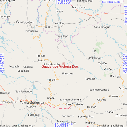
| Map corner | latitude | longitude |
|---|---|---|
| Upper-left | 17.8353°, | -93.46757° |
| Center: | 17.16472°, | -92.76444° |
| Lower-right: | 16.49171°, | -92.06132° |
| Map W x H: | 149.4×149.4 km | = 92.8×92.8mi |
| max Lat: | 32.7° ⇑86.9% North |
| Guadalupe Victoria Dos: | 17.16472° |
| min Lat: | ⇓13.1% South 14.53588° |
| min Long | Guadalupe Victo | max Long |
| -117.105° | -92.76444° | -86.73105° |
| W 90%⇐ | ⇒10% E |
Elevation
Elevation of Guadalupe Victoria Dos is 646 m = 2119 ft, and this is 607.7 m = 1994 ft below average elevation for this country.
| Max E: |
3497 m = 11473 ft | 65.8% |
| Avg. | 1253.7 m = 4113 ft | |
| Guadalupe Victoria Dos | 646 m = 2119 ft | |
Min E: |
-1 m = -3 ft | 34.2% |
See also: Mexico elevation on elevation.city.
Geographical zone
Guadalupe Victoria Dos is located in North Torrid zone (between Equator and Tropic of Cancer). Distance of this Northern Tropic circle is 697.4 km =433.3 mi to North.| Distance of | km | miles | from Guadalupe Victoria Dos |
|---|---|---|---|
| North Pole | 8098.5 | 5032.2 | to North |
| Arctic Circle | 5492.6 | 3412.9 | to North |
| Tropic Cancer | 697.4 | 433.3 | to North |
| Equator | 1908.5 | 1185.9 | to South |


Nearby cities:
15 places around Guadalupe Victoria Dos: (largest is in red/bold)
• Altamirano
6.8 km =4.2 mi,  211°
211°
• Carmen Zacatal
10.2 km =6.3 mi,  203°
203°
• Cálido
7.7 km =4.8 mi, 198°
• El Ocotal
4.2 km =2.6 mi,  17°
17°
• Huitiupán
8.4 km =5.2 mi,  84°
84°
• La Competencia
7.9 km =4.9 mi,  5°
5°
• La Pimienta
2.6 km =1.6 mi,  174°
174°
• Lázaro Cárdenas
8.3 km =5.2 mi,  290°
290°
• Rivera Galeana
4.8 km =3 mi, 204°
• San Andrés Duraznal
5.7 km =3.5 mi,  229°
229°
• San Rafael
4.5 km =2.8 mi,  334°
334°
• Simojovel de Allende
6 km =3.7 mi,  116°
116°
• Sonora
7.6 km =4.7 mi,  276°
276°
• Yuquín
7.9 km =4.9 mi,  162°
162°
• Zacajtic
9.6 km =6 mi,  1°
1°
Sources, notices
• [Note1] Compared only with cities in Mexico existing in our database
• [Src1] Map data: © OpenStreetMap contributors (CC-BY-SA)
• [Src2] Other city data from geonames.org with taken over terms of usage.
• [Src3] Geographical zone / Annual Mean Temperature by Robert A. Rohde @ Wikipedia
