Simojovel de Allende geodata
Simojovel de Allende (Chiapas) is a seat of a second-order administrative division; located in Mexico in America/Mexico_City (GMT-6) time zone. With population of 10,762 people, there are 881 cities with bigger population in this country. Compared to other cities in Mexico, 87.2% of cities are located further ↑North; 90.4% of cities are located further ←West and 64.8% of cities have higher elevation than Simojovel de Allende. Note1


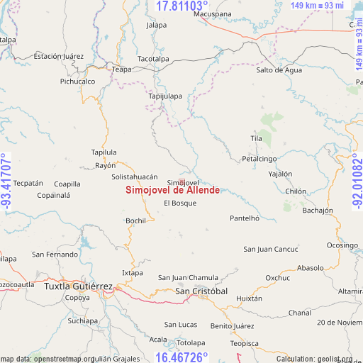
Simojovel de Allende GPS coordinates[2]
17° 8' 25.296" North, 92° 42' 50.184" West
| Map corner | latitude | longitude |
|---|---|---|
| Upper-left | 17.81103°, | -93.41707° |
| Center: | 17.14036°, | -92.71394° |
| Lower-right: | 16.46726°, | -92.01082° |
| Map W x H: | 149.4×149.4 km | = 92.8×92.8mi |
| max Lat: | 32.7° ⇑87.2% North |
| Simojovel de Allende: | 17.14036° |
| min Lat: | ⇓12.8% South 14.53588° |
| min Long | Simojovel de Al | max Long |
| -117.105° | -92.71394° | -86.73105° |
| W 90.4%⇐ | ⇒9.6% E |
Elevation
Elevation of Simojovel de Allende is 700 m = 2297 ft, and this is 553.7 m = 1817 ft below average elevation for this country.
| Max E: |
3497 m = 11473 ft | 64.8% |
| Avg. | 1253.7 m = 4113 ft | |
| Simojovel de Allende | 700 m = 2297 ft | |
Min E: |
-1 m = -3 ft | 35.2% |
See also: Mexico elevation on elevation.city.
Geographical zone
Simojovel de Allende is located in North Torrid zone (between Equator and Tropic of Cancer). Distance of this Northern Tropic circle is 700.1 km =435 mi to North.| Distance of | km | miles | from Simojovel de Allende |
|---|---|---|---|
| North Pole | 8101.2 | 5033.9 | to North |
| Arctic Circle | 5495.3 | 3414.6 | to North |
| Tropic Cancer | 700.1 | 435 | to North |
| Equator | 1905.8 | 1184.2 | to South |


Nearby cities:
15 places around Simojovel de Allende: (largest is in red/bold)
• Altamirano
9.5 km =5.9 mi,  251°
251°
• Chabajebal
10.8 km =6.7 mi,  163°
163°
• Cálido
9.1 km =5.7 mi,  239°
239°
• El Azufre
10.2 km =6.3 mi,  45°
45°
• El Bosque
8.7 km =5.4 mi,  185°
185°
• El Ocotal
7.9 km =4.9 mi,  328°
328°
• Guadalupe Victoria Dos
6 km =3.7 mi,  296°
296°
• Huitiupán
4.6 km =2.9 mi,  39°
39°
• La Pimienta
5.1 km =3.2 mi,  270°
270°
• Las Limas
5.1 km =3.2 mi, 161°
• Natividad Pechuag
10.8 km =6.7 mi,  109°
109°
• Rivera Galeana
7.6 km =4.7 mi,  257°
257°
• San Andrés Duraznal
9.7 km =6 mi, 264°
• San Rafael
10 km =6.2 mi,  312°
312°
• Yuquín
5.7 km =3.5 mi,  211°
211°
Sources, notices
• [Note1] Compared only with cities in Mexico existing in our database
• [Src1] Map data: © OpenStreetMap contributors (CC-BY-SA)
• [Src2] Other city data from geonames.org with taken over terms of usage.
• [Src3] Geographical zone / Annual Mean Temperature by Robert A. Rohde @ Wikipedia
