El Ocotal geodata
El Ocotal (Chiapas) is a populated place; located in Mexico in America/Mexico_City (GMT-6) time zone. With population of 753 people, there are 11637 cities with bigger population in this country. Compared to other cities in Mexico, 86.6% of cities are located further ↑North; 90.1% of cities are located further ←West and 59.6% of cities have higher elevation than El Ocotal. Note1


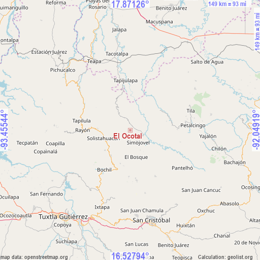
El Ocotal GPS coordinates[2]
17° 12' 2.952" North, 92° 45' 8.316" West
| Map corner | latitude | longitude |
|---|---|---|
| Upper-left | 17.87126°, | -93.45544° |
| Center: | 17.20082°, | -92.75231° |
| Lower-right: | 16.52794°, | -92.04919° |
| Map W x H: | 149.4×149.4 km | = 92.8×92.8mi |
| max Lat: | 32.7° ⇑86.6% North |
| El Ocotal: | 17.20082° |
| min Lat: | ⇓13.4% South 14.53588° |
| min Long | El Ocotal | max Long |
| -117.105° | -92.75231° | -86.73105° |
| W 90.1%⇐ | ⇒9.9% E |
Elevation
Elevation of El Ocotal is 1021 m = 3350 ft, and this is 232.7 m = 763 ft below average elevation for this country.
| Max E: |
3497 m = 11473 ft | 59.6% |
| Avg. | 1253.7 m = 4113 ft | |
| El Ocotal | 1021 m = 3350 ft | |
Min E: |
-1 m = -3 ft | 40.4% |
See also: Mexico elevation on elevation.city.
Geographical zone
El Ocotal is located in North Torrid zone (between Equator and Tropic of Cancer). Distance of this Northern Tropic circle is 693.4 km =430.9 mi to North.| Distance of | km | miles | from El Ocotal |
|---|---|---|---|
| North Pole | 8094.5 | 5029.7 | to North |
| Arctic Circle | 5488.6 | 3410.5 | to North |
| Tropic Cancer | 693.4 | 430.9 | to North |
| Equator | 1912.6 | 1188.4 | to South |


Nearby cities:
15 places around El Ocotal: (largest is in red/bold)
• Guadalupe Victoria Dos
4.2 km =2.6 mi,  197°
197°
• Huitiupán
7.7 km =4.8 mi,  114°
114°
• José María Morelos y Pavón
6.9 km =4.3 mi,  49°
49°
• La Competencia
3.9 km =2.4 mi,  352°
352°
• La Pimienta
6.7 km =4.2 mi,  189°
189°
• Lázaro Cárdenas
9.1 km =5.7 mi,  262°
262°
• Ramos Cubilete
9.9 km =6.2 mi, 49°
• Rivera Galeana
9 km =5.6 mi, 201°
• San Andrés Duraznal
9.5 km =5.9 mi,  216°
216°
• San Rafael
3.2 km =2 mi,  270°
270°
• Simojovel de Allende
7.9 km =4.9 mi,  148°
148°
• Sonora
9.4 km =5.8 mi,  250°
250°
• Villa Luz
9.6 km =6 mi,  22°
22°
• Zacajtic
5.7 km =3.5 mi, 349°
• Zacatonal de Juárez
9.3 km =5.8 mi,  327°
327°
Sources, notices
• [Note1] Compared only with cities in Mexico existing in our database
• [Src1] Map data: © OpenStreetMap contributors (CC-BY-SA)
• [Src2] Other city data from geonames.org with taken over terms of usage.
• [Src3] Geographical zone / Annual Mean Temperature by Robert A. Rohde @ Wikipedia
