Rivera Galeana geodata
Rivera Galeana (Chiapas) is a populated place; located in Mexico in America/Mexico_City (GMT-6) time zone. With population of 786 people, there are 11112 cities with bigger population in this country. Compared to other cities in Mexico, 87.4% of cities are located further ↑North; 89.9% of cities are located further ←West and 57.2% of cities have higher elevation than Rivera Galeana. Note1


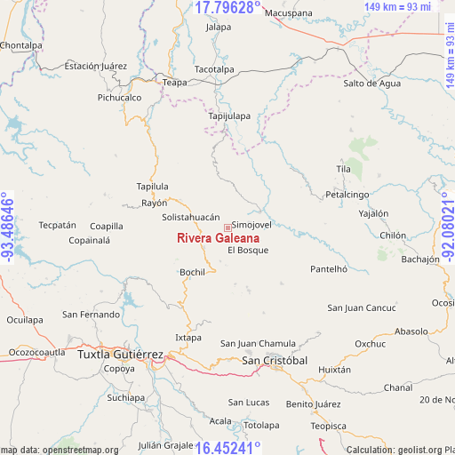
Rivera Galeana GPS coordinates[2]
17° 7' 32.016" North, 92° 46' 59.988" West
| Map corner | latitude | longitude |
|---|---|---|
| Upper-left | 17.79628°, | -93.48646° |
| Center: | 17.12556°, | -92.78333° |
| Lower-right: | 16.45241°, | -92.08021° |
| Map W x H: | 149.4×149.4 km | = 92.8×92.8mi |
| max Lat: | 32.7° ⇑87.4% North |
| Rivera Galeana: | 17.12556° |
| min Lat: | ⇓12.6% South 14.53588° |
| min Long | Rivera Galeana | max Long |
| -117.105° | -92.78333° | -86.73105° |
| W 89.9%⇐ | ⇒10.1% E |
Elevation
Elevation of Rivera Galeana is 1118 m = 3668 ft, and this is 135.7 m = 445 ft below average elevation for this country.
| Max E: |
3497 m = 11473 ft | 57.2% |
| Avg. | 1253.7 m = 4113 ft | |
| Rivera Galeana | 1118 m = 3668 ft | |
Min E: |
-1 m = -3 ft | 42.8% |
See also: Mexico elevation on elevation.city.
Geographical zone
Rivera Galeana is located in North Torrid zone (between Equator and Tropic of Cancer). Distance of this Northern Tropic circle is 701.7 km =436 mi to North.| Distance of | km | miles | from Rivera Galeana |
|---|---|---|---|
| North Pole | 8102.9 | 5034.9 | to North |
| Arctic Circle | 5497 | 3415.7 | to North |
| Tropic Cancer | 701.7 | 436 | to North |
| Equator | 1904.2 | 1183.2 | to South |


Nearby cities:
15 places around Rivera Galeana: (largest is in red/bold)
• Altamirano
2.1 km =1.3 mi,  228°
228°
• Carmen Zacatal
5.4 km =3.4 mi,  202°
202°
• Cálido
3 km =1.9 mi,  188°
188°
• El Bosque
9.6 km =6 mi,  136°
136°
• El Ocotal
9 km =5.6 mi,  21°
21°
• Guadalupe Victoria Dos
4.8 km =3 mi, 24°
• La Pimienta
2.8 km =1.7 mi,  52°
52°
• Las Limas
9.5 km =5.9 mi,  109°
109°
• Lázaro Cárdenas
9.2 km =5.7 mi,  321°
321°
• San Andrés Duraznal
2.4 km =1.5 mi,  286°
286°
• San Rafael
8.4 km =5.2 mi,  0°
0°
• Simojovel de Allende
7.6 km =4.7 mi,  77°
77°
• Sonora
7.7 km =4.8 mi,  313°
313°
• Unión Zaragoza
8.3 km =5.2 mi, 233°
• Yuquín
5.4 km =3.4 mi,  126°
126°
Sources, notices
• [Note1] Compared only with cities in Mexico existing in our database
• [Src1] Map data: © OpenStreetMap contributors (CC-BY-SA)
• [Src2] Other city data from geonames.org with taken over terms of usage.
• [Src3] Geographical zone / Annual Mean Temperature by Robert A. Rohde @ Wikipedia
