Champilico geodata
Champilico (Veracruz) is a populated place; located in Mexico in America/Mexico_City (GMT-6) time zone. With population of 939 people, there are 9278 cities with bigger population in this country. Compared to other cities in Mexico, 51.4% of cities are located further ↓South; 71.9% of cities are located further ←West and 76.9% of cities have lower elevation than Champilico. Note1


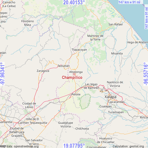
Champilico GPS coordinates[2]
19° 44' 27.996" North, 97° 15' 37.008" West
| Map corner | latitude | longitude |
|---|---|---|
| Upper-left | 20.40153°, | -97.96341° |
| Center: | 19.74111°, | -97.26028° |
| Lower-right: | 19.07795°, | -96.55716° |
| Map W x H: | 147.2×147.2 km | = 91.5×91.5mi |
| max Lat: | 32.7° ⇑48.6% North |
| Champilico: | 19.74111° |
| min Lat: | ⇓51.4% South 14.53588° |
| min Long | Champilico | max Long |
| -117.105° | -97.26028° | -86.73105° |
| W 71.9%⇐ | ⇒28.1% E |
Elevation
Elevation of Champilico is 2064 m = 6772 ft, and this is 810.3 m = 2658 ft above average elevation for this country.
| Max E: |
3497 m = 11473 ft | 23.1% |
| Champilico | 2064 m 6772 ft | |
| Avg. | 1253.7 m = 4113 ft | |
Min E: |
-1 m = -3 ft | 76.9% |
See also: Mexico elevation on elevation.city.
Geographical zone
Champilico is located in North Torrid zone (between Equator and Tropic of Cancer). Distance of this Northern Tropic circle is 410.9 km =255.3 mi to North.| Distance of | km | miles | from Champilico |
|---|---|---|---|
| North Pole | 7812.1 | 4854.2 | to North |
| Arctic Circle | 5206.2 | 3235 | to North |
| Tropic Cancer | 410.9 | 255.3 | to North |
| Equator | 2195 | 1363.9 | to South |


Nearby cities:
15 places around Champilico: (largest is in red/bold)
• Adolfo Moreno
3 km =1.9 mi,  128°
128°
• Ahueyahualco
2.4 km =1.5 mi,  178°
178°
• Altotonga
3.2 km =2 mi,  29°
29°
• Buena Vista
3.8 km =2.4 mi,  72°
72°
• Calpulalpan
3.4 km =2.1 mi,  218°
218°
• Ignacio Zaragoza
4.9 km =3 mi, 131°
• Loma de Hidalgo
3.8 km =2.4 mi,  280°
280°
• Miguel Hidalgo
2.9 km =1.8 mi,  308°
308°
• Mixquiapan
4.8 km =3 mi,  203°
203°
• San Miguel Tlalpoalán
3.5 km =2.2 mi,  92°
92°
• Tepiolulco
3.3 km =2.1 mi,  145°
145°
• Texacaxco
2.7 km =1.7 mi,  355°
355°
• Veintiuno de Agosto
2.2 km =1.4 mi,  214°
214°
• Xoampolco
3.9 km =2.4 mi,  56°
56°
• Zoatzingo
1.9 km =1.2 mi,  143°
143°
Sources, notices
• [Note1] Compared only with cities in Mexico existing in our database
• [Src1] Map data: © OpenStreetMap contributors (CC-BY-SA)
• [Src2] Other city data from geonames.org with taken over terms of usage.
• [Src3] Geographical zone / Annual Mean Temperature by Robert A. Rohde @ Wikipedia
