Altotonga geodata
Altotonga (Veracruz) is a seat of a second-order administrative division; located in Mexico in America/Mexico_City (GMT-6) time zone. With population of 19,722 people, there are 506 cities with bigger population in this country. Compared to other cities in Mexico, 51.8% of cities are located further ↓South; 72% of cities are located further ←West and 68.3% of cities have lower elevation than Altotonga. Note1


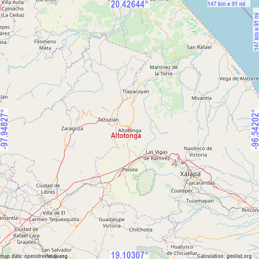
Altotonga GPS coordinates[2]
19° 45' 58.068" North, 97° 14' 42.504" West
| Map corner | latitude | longitude |
|---|---|---|
| Upper-left | 20.42644°, | -97.94827° |
| Center: | 19.76613°, | -97.24514° |
| Lower-right: | 19.10307°, | -96.54202° |
| Map W x H: | 147.1×147.1 km | = 91.4×91.4mi |
| max Lat: | 32.7° ⇑48.2% North |
| Altotonga: | 19.76613° |
| min Lat: | ⇓51.8% South 14.53588° |
| min Long | Altotonga | max Long |
| -117.105° | -97.24514° | -86.73105° |
| W 72%⇐ | ⇒28% E |
Elevation
Elevation of Altotonga is 1895 m = 6217 ft, and this is 641.3 m = 2104 ft above average elevation for this country.
| Max E: |
3497 m = 11473 ft | 31.7% |
| Altotonga | 1895 m 6217 ft | |
| Avg. | 1253.7 m = 4113 ft | |
Min E: |
-1 m = -3 ft | 68.3% |
See also: Mexico elevation on elevation.city.
Geographical zone
Altotonga is located in North Torrid zone (between Equator and Tropic of Cancer). Distance of this Northern Tropic circle is 408.1 km =253.6 mi to North.| Distance of | km | miles | from Altotonga |
|---|---|---|---|
| North Pole | 7809.3 | 4852.5 | to North |
| Arctic Circle | 5203.4 | 3233.2 | to North |
| Tropic Cancer | 408.1 | 253.6 | to North |
| Equator | 2197.8 | 1365.6 | to South |


Nearby cities:
15 places around Altotonga: (largest is in red/bold)
• Adolfo Moreno
4.7 km =2.9 mi,  170°
170°
• Ahueyahualco
5.4 km =3.4 mi,  196°
196°
• Atzalan
2.5 km =1.6 mi,  7°
7°
• Buena Vista
2.6 km =1.6 mi,  129°
129°
• Champilico
3.2 km =2 mi,  209°
209°
• Ictzictic
5.1 km =3.2 mi,  61°
61°
• La Florida
3.8 km =2.4 mi,  1°
1°
• Miguel Hidalgo
4 km =2.5 mi,  256°
256°
• Ocotepec
5.5 km =3.4 mi,  326°
326°
• San Miguel Tlalpoalán
3.5 km =2.2 mi,  146°
146°
• Tepiolulco
5.5 km =3.4 mi,  177°
177°
• Texacaxco
1.8 km =1.1 mi,  265°
265°
• Veintiuno de Agosto
5.4 km =3.4 mi, 211°
• Xoampolco
1.7 km =1.1 mi,  110°
110°
• Zoatzingo
4.3 km =2.7 mi,  185°
185°
Sources, notices
• [Note1] Compared only with cities in Mexico existing in our database
• [Src1] Map data: © OpenStreetMap contributors (CC-BY-SA)
• [Src2] Other city data from geonames.org with taken over terms of usage.
• [Src3] Geographical zone / Annual Mean Temperature by Robert A. Rohde @ Wikipedia
