Ignacio Pérez geodata
Ignacio Pérez (Querétaro) is a populated place; located in Mexico in America/Mexico_City (GMT-6) time zone. With population of 1,773 people, there are 4895 cities with bigger population in this country. Compared to other cities in Mexico, 68.2% of cities are located further ↓South; 65.3% of cities are located further →East and 70.2% of cities have lower elevation than Ignacio Pérez. Note1


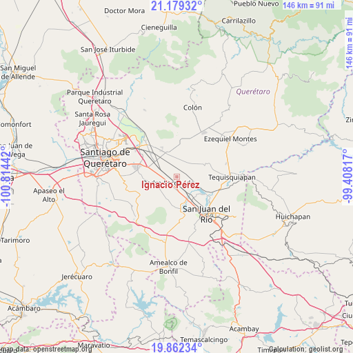
Ignacio Pérez GPS coordinates[2]
20° 31' 20.1" North, 100° 6' 40.644" West
| Map corner | latitude | longitude |
|---|---|---|
| Upper-left | 21.17932°, | -100.81442° |
| Center: | 20.52225°, | -100.11129° |
| Lower-right: | 19.86234°, | -99.40817° |
| Map W x H: | 146.4×146.4 km | = 91×91mi |
| max Lat: | 32.7° ⇑31.8% North |
| Ignacio Pérez: | 20.52225° |
| min Lat: | ⇓68.2% South 14.53588° |
| min Long | Ignacio Pérez | max Long |
| -117.105° | -100.11129° | -86.73105° |
| W 34.7%⇐ | ⇒65.3% E |
Elevation
Elevation of Ignacio Pérez is 1928 m = 6325 ft, and this is 674.3 m = 2212 ft above average elevation for this country.
| Max E: |
3497 m = 11473 ft | 29.8% |
| Ignacio Pérez | 1928 m 6325 ft | |
| Avg. | 1253.7 m = 4113 ft | |
Min E: |
-1 m = -3 ft | 70.2% |
See also: Mexico elevation on elevation.city.
Geographical zone
Ignacio Pérez is located in North Torrid zone (between Equator and Tropic of Cancer). Distance of this Northern Tropic circle is 324.1 km =201.4 mi to North.| Distance of | km | miles | from Ignacio Pérez |
|---|---|---|---|
| North Pole | 7725.2 | 4800.2 | to North |
| Arctic Circle | 5119.3 | 3181 | to North |
| Tropic Cancer | 324.1 | 201.4 | to North |
| Equator | 2281.9 | 1417.9 | to South |


Nearby cities:
15 places around Ignacio Pérez: (largest is in red/bold)
• El Organal
7.7 km =4.8 mi,  130°
130°
• El Saúz
5 km =3.1 mi,  184°
184°
• Epigmenio González
6.4 km =4 mi,  299°
299°
• Guadalupe Septién
0.6 km =0.4 mi,  338°
338°
• La Lira
7.4 km =4.6 mi,  225°
225°
• La Palma
6.5 km =4 mi,  269°
269°
• Los Cerritos
6.7 km =4.2 mi,  48°
48°
• Los Álvarez
4.4 km =2.7 mi,  317°
317°
• México Lindo
6.3 km =3.9 mi,  5°
5°
• Noria Nueva
4.1 km =2.5 mi, 339°
• Pedro Escobedo
4.1 km =2.5 mi, 232°
• Quintanares
2.9 km =1.8 mi,  277°
277°
• San Clemente
2.9 km =1.8 mi,  105°
105°
• San Francisco
7 km =4.3 mi, 339°
• San Vicente el Alto
7.6 km =4.7 mi,  312°
312°
Sources, notices
• [Note1] Compared only with cities in Mexico existing in our database
• [Src1] Map data: © OpenStreetMap contributors (CC-BY-SA)
• [Src2] Other city data from geonames.org with taken over terms of usage.
• [Src3] Geographical zone / Annual Mean Temperature by Robert A. Rohde @ Wikipedia
