San Clemente geodata
San Clemente (Querétaro) is a populated place; located in Mexico in America/Mexico_City (GMT-6) time zone. With population of 4,852 people, there are 1908 cities with bigger population in this country. Compared to other cities in Mexico, 68.1% of cities are located further ↓South; 65% of cities are located further →East and 69.9% of cities have lower elevation than San Clemente. Note1


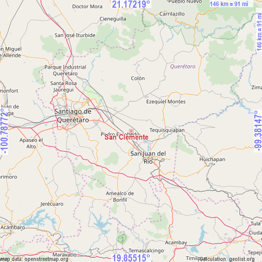
San Clemente GPS coordinates[2]
20° 30' 54.324" North, 100° 5' 4.524" West
| Map corner | latitude | longitude |
|---|---|---|
| Upper-left | 21.17219°, | -100.78772° |
| Center: | 20.51509°, | -100.08459° |
| Lower-right: | 19.85515°, | -99.38147° |
| Map W x H: | 146.4×146.4 km | = 91×91mi |
| max Lat: | 32.7° ⇑31.9% North |
| San Clemente: | 20.51509° |
| min Lat: | ⇓68.1% South 14.53588° |
| min Long | San Clemente | max Long |
| -117.105° | -100.08459° | -86.73105° |
| W 35%⇐ | ⇒65% E |
Elevation
Elevation of San Clemente is 1921 m = 6302 ft, and this is 667.3 m = 2189 ft above average elevation for this country.
| Max E: |
3497 m = 11473 ft | 30.1% |
| San Clemente | 1921 m 6302 ft | |
| Avg. | 1253.7 m = 4113 ft | |
Min E: |
-1 m = -3 ft | 69.9% |
See also: Mexico elevation on elevation.city.
Geographical zone
San Clemente is located in North Torrid zone (between Equator and Tropic of Cancer). Distance of this Northern Tropic circle is 324.9 km =201.9 mi to North.| Distance of | km | miles | from San Clemente |
|---|---|---|---|
| North Pole | 7726 | 4800.7 | to North |
| Arctic Circle | 5120.1 | 3181.5 | to North |
| Tropic Cancer | 324.9 | 201.9 | to North |
| Equator | 2281.1 | 1417.4 | to South |


Nearby cities:
15 places around San Clemente: (largest is in red/bold)
• El Organal
5.2 km =3.2 mi,  143°
143°
• El Saúz
5.2 km =3.2 mi,  217°
217°
• Guadalupe Septién
3.3 km =2.1 mi,  294°
294°
• Ignacio Pérez
2.9 km =1.8 mi, 285°
• La Fuente
6.6 km =4.1 mi,  50°
50°
• La Valla
6.2 km =3.9 mi,  105°
105°
• Laguna de Lourdes
5.5 km =3.4 mi, 136°
• Los Cerritos
5.7 km =3.5 mi,  22°
22°
• Los Álvarez
7.1 km =4.4 mi,  305°
305°
• México Lindo
7.4 km =4.6 mi,  343°
343°
• Noria Nueva
6.3 km =3.9 mi,  317°
317°
• Pedro Escobedo
6.3 km =3.9 mi,  254°
254°
• Quintanares
5.7 km =3.5 mi,  281°
281°
• San Germán
6.9 km =4.3 mi,  154°
154°
• San Javier
7.2 km =4.5 mi,  160°
160°
Sources, notices
• [Note1] Compared only with cities in Mexico existing in our database
• [Src1] Map data: © OpenStreetMap contributors (CC-BY-SA)
• [Src2] Other city data from geonames.org with taken over terms of usage.
• [Src3] Geographical zone / Annual Mean Temperature by Robert A. Rohde @ Wikipedia
