Chichimila geodata
Chichimila (Yucatán) is a populated place; located in Mexico in America/Merida (GMT-6) time zone. With population of 5,528 people, there are 1687 cities with bigger population in this country. Compared to other cities in Mexico, 70.6% of cities are located further ↓South; 99.6% of cities are located further ←West and 89.4% of cities have higher elevation than Chichimila. Note1


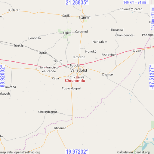
Chichimila GPS coordinates[2]
20° 37' 54.336" North, 88° 13' 0.804" West
| Map corner | latitude | longitude |
|---|---|---|
| Upper-left | 21.28835°, | -88.92002° |
| Center: | 20.63176°, | -88.21689° |
| Lower-right: | 19.97232°, | -87.51377° |
| Map W x H: | 146.3×146.3 km | = 90.9×90.9mi |
| max Lat: | 32.7° ⇑29.4% North |
| Chichimila: | 20.63176° |
| min Lat: | ⇓70.6% South 14.53588° |
| min Long | Chichimila | max Long |
| -117.105° | -88.21689° | -86.73105° |
| W 99.6%⇐ | ⇒0.40000000000001% E |
Elevation
Elevation of Chichimila is 26 m = 85 ft, and this is 1227.7 m = 4028 ft below average elevation for this country.
| Max E: |
3497 m = 11473 ft | 89.4% |
| Avg. | 1253.7 m = 4113 ft | |
| Chichimila | 26 m = 85 ft | |
Min E: |
-1 m = -3 ft | 10.6% |
See also: Mexico elevation on elevation.city.
Geographical zone
Chichimila is located in North Torrid zone (between Equator and Tropic of Cancer). Distance of this Northern Tropic circle is 311.9 km =193.8 mi to North.| Distance of | km | miles | from Chichimila |
|---|---|---|---|
| North Pole | 7713 | 4792.6 | to North |
| Arctic Circle | 5107.1 | 3173.4 | to North |
| Tropic Cancer | 311.9 | 193.8 | to North |
| Equator | 2294 | 1425.4 | to South |


Nearby cities:
15 places around Chichimila: (largest is in red/bold)
• Cuncunul
8.4 km =5.2 mi,  276°
276°
• Dzitnup
3.4 km =2.1 mi,  300°
300°
• Ebtun
5.7 km =3.5 mi,  309°
309°
• Kanxoc
12.5 km =7.8 mi,  98°
98°
• Pixoy
10.6 km =6.6 mi,  332°
332°
• Popola
11.5 km =7.1 mi,  349°
349°
• Tahmuy
16.2 km =10.1 mi,  28°
28°
• Tekom
5.9 km =3.7 mi,  237°
237°
• Tesoco
12 km =7.5 mi, 32°
• Tikuch
13.4 km =8.3 mi,  53°
53°
• Tixcacalcupul
12 km =7.5 mi,  207°
207°
• Tixhualactún
7.8 km =4.8 mi,  79°
79°
• Uayma
14.1 km =8.8 mi, 312°
• Valladolid
6.5 km =4 mi,  16°
16°
• Xocen
6.7 km =4.2 mi,  124°
124°
Sources, notices
• [Note1] Compared only with cities in Mexico existing in our database
• [Src1] Map data: © OpenStreetMap contributors (CC-BY-SA)
• [Src2] Other city data from geonames.org with taken over terms of usage.
• [Src3] Geographical zone / Annual Mean Temperature by Robert A. Rohde @ Wikipedia
