Tekom geodata
Tekom (Yucatán) is a populated place; located in Mexico in America/Merida (GMT-6) time zone. With population of 2,540 people, there are 3488 cities with bigger population in this country. Compared to other cities in Mexico, 70% of cities are located further ↓South; 99.5% of cities are located further ←West and 88.6% of cities have higher elevation than Tekom. Note1


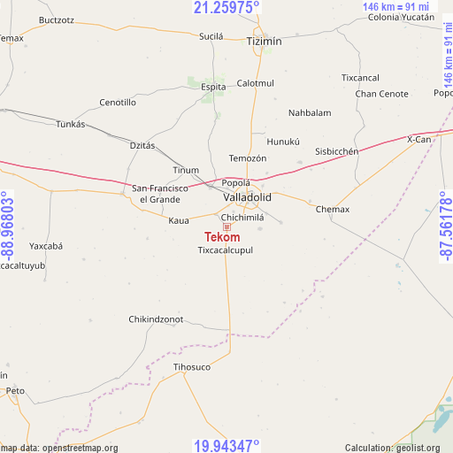
Tekom GPS coordinates[2]
20° 36' 10.908" North, 88° 15' 53.64" West
| Map corner | latitude | longitude |
|---|---|---|
| Upper-left | 21.25975°, | -88.96803° |
| Center: | 20.60303°, | -88.2649° |
| Lower-right: | 19.94347°, | -87.56178° |
| Map W x H: | 146.4×146.4 km | = 91×91mi |
| max Lat: | 32.7° ⇑30% North |
| Tekom: | 20.60303° |
| min Lat: | ⇓70% South 14.53588° |
| min Long | Tekom | max Long |
| -117.105° | -88.2649° | -86.73105° |
| W 99.5%⇐ | ⇒0.5% E |
Elevation
Elevation of Tekom is 28 m = 92 ft, and this is 1225.7 m = 4021 ft below average elevation for this country.
| Max E: |
3497 m = 11473 ft | 88.6% |
| Avg. | 1253.7 m = 4113 ft | |
| Tekom | 28 m = 92 ft | |
Min E: |
-1 m = -3 ft | 11.4% |
See also: Mexico elevation on elevation.city.
Geographical zone
Tekom is located in North Torrid zone (between Equator and Tropic of Cancer). Distance of this Northern Tropic circle is 315.1 km =195.8 mi to North.| Distance of | km | miles | from Tekom |
|---|---|---|---|
| North Pole | 7716.2 | 4794.6 | to North |
| Arctic Circle | 5110.3 | 3175.4 | to North |
| Tropic Cancer | 315.1 | 195.8 | to North |
| Equator | 2290.8 | 1423.4 | to South |


Nearby cities:
15 places around Tekom: (largest is in red/bold)
• Chichimila
5.9 km =3.7 mi,  57°
57°
• Cuncunul
5.4 km =3.4 mi,  320°
320°
• Dzitnup
5.4 km =3.4 mi,  23°
23°
• Ebtun
6.8 km =4.2 mi,  4°
4°
• Kanxoc
17.5 km =10.9 mi,  85°
85°
• Kaua
15.8 km =9.8 mi,  277°
277°
• Pixoy
12.6 km =7.8 mi, 0°
• Popola
14.8 km =9.2 mi,  11°
11°
• Tesoco
17.6 km =10.9 mi,  40°
40°
• Tikuch
19.3 km =12 mi,  54°
54°
• Tixcacalcupul
7.5 km =4.7 mi,  184°
184°
• Tixhualactún
13.5 km =8.4 mi,  70°
70°
• Uayma
13.9 km =8.6 mi,  337°
337°
• Valladolid
11.7 km =7.3 mi, 35°
• Xocen
10.5 km =6.5 mi, 93°
Sources, notices
• [Note1] Compared only with cities in Mexico existing in our database
• [Src1] Map data: © OpenStreetMap contributors (CC-BY-SA)
• [Src2] Other city data from geonames.org with taken over terms of usage.
• [Src3] Geographical zone / Annual Mean Temperature by Robert A. Rohde @ Wikipedia
