Chan X-Cail geodata
Chan X-Cail (Yucatán) is a populated place; located in Mexico in America/Cancun (GMT-5) time zone. With population of 576 people, there are 14877 cities with bigger population in this country. Compared to other cities in Mexico, 64.7% of cities are located further ↓South; 99.6% of cities are located further ←West and 88.6% of cities have higher elevation than Chan X-Cail. Note1


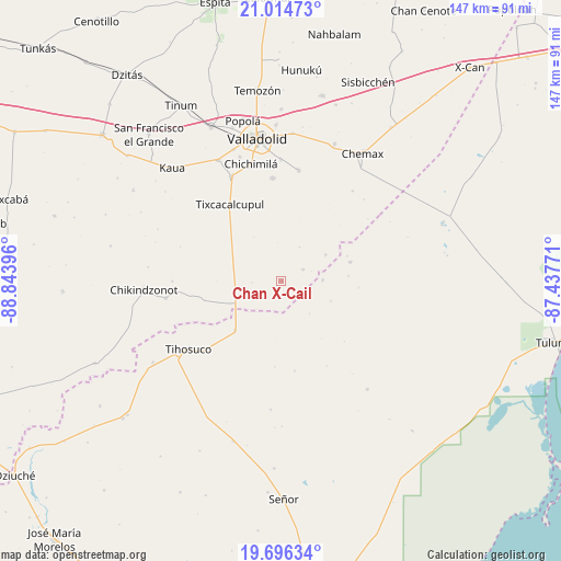
Chan X-Cail GPS coordinates[2]
20° 21' 24.984" North, 88° 8' 26.988" West
| Map corner | latitude | longitude |
|---|---|---|
| Upper-left | 21.01473°, | -88.84396° |
| Center: | 20.35694°, | -88.14083° |
| Lower-right: | 19.69634°, | -87.43771° |
| Map W x H: | 146.6×146.6 km | = 91.1×91.1mi |
| max Lat: | 32.7° ⇑35.3% North |
| Chan X-Cail: | 20.35694° |
| min Lat: | ⇓64.7% South 14.53588° |
| min Long | Chan X-Cail | max Long |
| -117.105° | -88.14083° | -86.73105° |
| W 99.6%⇐ | ⇒0.40000000000001% E |
Elevation
Elevation of Chan X-Cail is 28 m = 92 ft, and this is 1225.7 m = 4021 ft below average elevation for this country.
| Max E: |
3497 m = 11473 ft | 88.6% |
| Avg. | 1253.7 m = 4113 ft | |
| Chan X-Cail | 28 m = 92 ft | |
Min E: |
-1 m = -3 ft | 11.4% |
See also: Mexico elevation on elevation.city.
Geographical zone
Chan X-Cail is located in North Torrid zone (between Equator and Tropic of Cancer). Distance of this Northern Tropic circle is 342.4 km =212.8 mi to North.| Distance of | km | miles | from Chan X-Cail |
|---|---|---|---|
| North Pole | 7743.6 | 4811.6 | to North |
| Arctic Circle | 5137.7 | 3192.4 | to North |
| Tropic Cancer | 342.4 | 212.8 | to North |
| Equator | 2263.5 | 1406.5 | to South |


Nearby cities:
15 places around Chan X-Cail: (largest is in red/bold)
• Chanchen Primero
18.7 km =11.6 mi,  74°
74°
• Chichimila
31.6 km =19.6 mi,  345°
345°
• Chulutan
29.9 km =18.6 mi,  38°
38°
• Cuncunul
35.5 km =22.1 mi,  332°
332°
• Dzitnup
34 km =21.1 mi,  341°
341°
• Dzitox
6.3 km =3.9 mi,  62°
62°
• Ekpedz
30.5 km =19 mi,  261°
261°
• Kanxoc
29.1 km =18.1 mi,  8°
8°
• San Silverio
10.9 km =6.8 mi,  88°
88°
• Tekom
30.3 km =18.8 mi, 334°
• Tepich
17.6 km =10.9 mi,  223°
223°
• Tihosuco
30.1 km =18.7 mi,  233°
233°
• Tixcacalcupul
24.1 km =15 mi, 325°
• Tixhualactún
31.9 km =19.8 mi,  359°
359°
• Xocen
26.9 km =16.7 mi, 354°
Sources, notices
• [Note1] Compared only with cities in Mexico existing in our database
• [Src1] Map data: © OpenStreetMap contributors (CC-BY-SA)
• [Src2] Other city data from geonames.org with taken over terms of usage.
• [Src3] Geographical zone / Annual Mean Temperature by Robert A. Rohde @ Wikipedia
