La Loma (Loma de Enmedio) geodata
La Loma (Loma de Enmedio) (Jalisco) is a populated place; located in Mexico in America/Mexico_City (GMT-6) time zone. With population of 652 people, there are 13293 cities with bigger population in this country. Compared to other cities in Mexico, 73.3% of cities are located further ↓South; 85% of cities are located further →East and 65.5% of cities have lower elevation than La Loma (Loma de Enmedio). Note1
Current local time in La Loma (Loma de Enmedio):
05:34 AM, WednesdayDifference from your time zone: hours


La Loma (Loma de Enmedio) GPS coordinates[2]
20° 47' 53.016" North, 102° 44' 21.012" West
| Map corner | latitude | longitude |
|---|---|---|
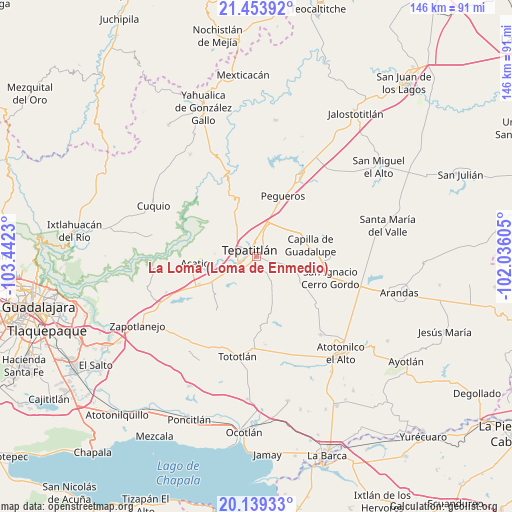
| Upper-left | 21.45392°, | -103.4423° |
| Center: | 20.79806°, | -102.73917° |
| Lower-right: | 20.13933°, | -102.03605° |
| Map W x H: | 146.2×146.2 km | = 90.8×90.8mi |
| max Lat: | 32.7° ⇑26.7% North |
| La Loma (Loma de Enmedio): | 20.79806° |
| min Lat: | ⇓73.3% South 14.53588° |
| min Long | La Loma (Loma d | max Long |
| -117.105° | -102.73917° | -86.73105° |
| W 15%⇐ | ⇒85% E |
Elevation
Elevation of La Loma (Loma de Enmedio) is 1842 m = 6043 ft, and this is 588.3 m = 1930 ft above average elevation for this country.
| Max E: |
3497 m = 11473 ft | 34.5% |
| La Loma (Loma de Enmedio) | 1842 m 6043 ft | |
| Avg. | 1253.7 m = 4113 ft | |
Min E: |
-1 m = -3 ft | 65.5% |
See also: Mexico elevation on elevation.city.
Geographical zone
La Loma (Loma de Enmedio) is located in North Torrid zone (between Equator and Tropic of Cancer). Distance of this Northern Tropic circle is 293.4 km =182.3 mi to North.| Distance of | km | miles | from La Loma (Loma de Enmedio) |
|---|---|---|---|
| North Pole | 7694.5 | 4781.1 | to North |
| Arctic Circle | 5088.6 | 3161.9 | to North |
| Tropic Cancer | 293.4 | 182.3 | to North |
| Equator | 2312.5 | 1436.9 | to South |


Nearby cities:
15 places around La Loma (Loma de Enmedio): (largest is in red/bold)
• Acatic
17.9 km =11.1 mi,  263°
263°
• Capilla de Guadalupe
15.7 km =9.8 mi,  77°
77°
• Capilla de Milpillas
18.5 km =11.5 mi,  215°
215°
• El Refugio
18.3 km =11.4 mi,  244°
244°
• Los Dolores
21.7 km =13.5 mi,  88°
88°
• Mezcala
20.5 km =12.7 mi,  327°
327°
• Ojo de Agua de Latillas
15 km =9.3 mi,  162°
162°
• Pegueros
18.8 km =11.7 mi,  23°
23°
• Ramblas Chico
21.1 km =13.1 mi,  200°
200°
• San Agustín
18.5 km =11.5 mi,  172°
172°
• San Ignacio Cerro Gordo
22 km =13.7 mi,  105°
105°
• San Isidro
25.2 km =15.7 mi, 174°
• San José de Gracia
22.3 km =13.9 mi,  127°
127°
• Tepatitlán de Morelos
3.3 km =2.1 mi,  309°
309°
• Tierras Coloradas
14.8 km =9.2 mi, 238°
Sources, notices
• [Note1] Compared only with cities in Mexico existing in our database
• [Src1] Map data: © OpenStreetMap contributors (CC-BY-SA)
• [Src2] Other city data from geonames.org with taken over terms of usage.
• [Src3] Geographical zone / Annual Mean Temperature by Robert A. Rohde @ Wikipedia
