Puente de Guadalupe geodata
Puente de Guadalupe (Veracruz) is a populated place; located in Mexico in America/Mexico_City (GMT-6) time zone. With population of 859 people, there are 10183 cities with bigger population in this country. Compared to other cities in Mexico, 69.7% of cities are located further ↑North; 72% of cities are located further ←West and 50.3% of cities have lower elevation than Puente de Guadalupe. Note1


Puente de Guadalupe GPS coordinates[2]
18° 44' 33" North, 97° 15' 0" West
| Map corner | latitude | longitude |
|---|---|---|
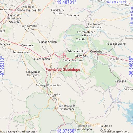
| Upper-left | 19.40701°, | -97.95313° |
| Center: | 18.7425°, | -97.25° |
| Lower-right: | 18.07536°, | -96.54688° |
| Map W x H: | 148.1×148.1 km | = 92×92mi |
| max Lat: | 32.7° ⇑69.7% North |
| Puente de Guadalupe: | 18.7425° |
| min Lat: | ⇓30.3% South 14.53588° |
| min Long | Puente de Guada | max Long |
| -117.105° | -97.25° | -86.73105° |
| W 72%⇐ | ⇒28% E |
Elevation
Elevation of Puente de Guadalupe is 1445 m = 4741 ft, and this is 191.3 m = 628 ft above average elevation for this country.
| Max E: |
3497 m = 11473 ft | 49.7% |
| Puente de Guadalupe | 1445 m 4741 ft | |
| Avg. | 1253.7 m = 4113 ft | |
Min E: |
-1 m = -3 ft | 50.3% |
See also: Mexico elevation on elevation.city.
Geographical zone
Puente de Guadalupe is located in North Torrid zone (between Equator and Tropic of Cancer). Distance of this Northern Tropic circle is 521.9 km =324.3 mi to North.| Distance of | km | miles | from Puente de Guadalupe |
|---|---|---|---|
| North Pole | 7923.1 | 4923.2 | to North |
| Arctic Circle | 5317.2 | 3304 | to North |
| Tropic Cancer | 521.9 | 324.3 | to North |
| Equator | 2084 | 1294.9 | to South |


Nearby cities:
15 places around Puente de Guadalupe: (largest is in red/bold)
• Acatla
3.4 km =2.1 mi,  76°
76°
• Acultzingo
6.2 km =3.9 mi,  245°
245°
• Aguachinola
4.3 km =2.7 mi,  49°
49°
• Coatepec de Abajo (Rincón Lobo)
4 km =2.5 mi,  190°
190°
• Coxolitla de Abajo
0.8 km =0.5 mi,  63°
63°
• El Campanario
6.8 km =4.2 mi, 61°
• Huiloapan
7.1 km =4.4 mi,  276°
276°
• Huixtitla
6 km =3.7 mi, 80°
• Próspero Pineda
0.3 km =0.2 mi,  323°
323°
• Rancho Viejo
6.4 km =4 mi,  42°
42°
• Sierra de Agua
1.2 km =0.7 mi, 45°
• Soledad Atzompa
7.2 km =4.5 mi,  105°
105°
• Taza de Agua Ojo Zarco
6.8 km =4.2 mi, 47°
• Tecamalucan
3.3 km =2.1 mi, 51°
• Xiquila
6.9 km =4.3 mi,  121°
121°
Sources, notices
• [Note1] Compared only with cities in Mexico existing in our database
• [Src1] Map data: © OpenStreetMap contributors (CC-BY-SA)
• [Src2] Other city data from geonames.org with taken over terms of usage.
• [Src3] Geographical zone / Annual Mean Temperature by Robert A. Rohde @ Wikipedia
