Guadalupe Chico geodata
Guadalupe Chico (State of Mexico) is a populated place; located in Mexico in America/Mexico_City (GMT-6) time zone. With population of 835 people, there are 10477 cities with bigger population in this country. Compared to other cities in Mexico, 51.9% of cities are located further ↑North; 65.6% of cities are located further →East and 97.4% of cities have lower elevation than Guadalupe Chico. Note1


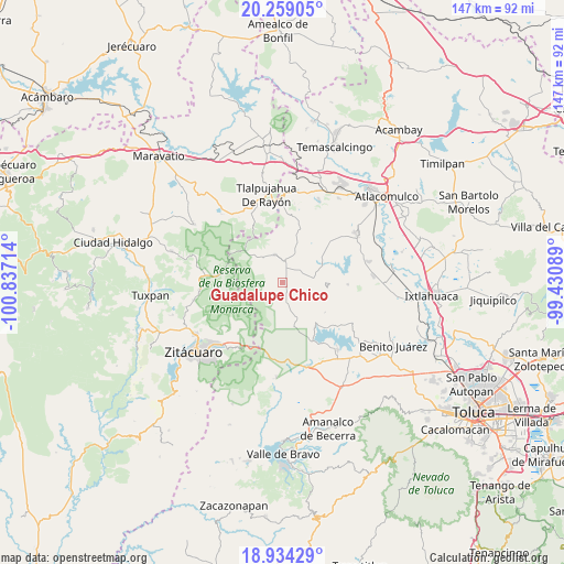
Guadalupe Chico GPS coordinates[2]
19° 35' 52.908" North, 100° 8' 2.436" West
| Map corner | latitude | longitude |
|---|---|---|
| Upper-left | 20.25905°, | -100.83714° |
| Center: | 19.59803°, | -100.13401° |
| Lower-right: | 18.93429°, | -99.43089° |
| Map W x H: | 147.3×147.3 km | = 91.5×91.5mi |
| max Lat: | 32.7° ⇑51.9% North |
| Guadalupe Chico: | 19.59803° |
| min Lat: | ⇓48.1% South 14.53588° |
| min Long | Guadalupe Chico | max Long |
| -117.105° | -100.13401° | -86.73105° |
| W 34.4%⇐ | ⇒65.6% E |
Elevation
Elevation of Guadalupe Chico is 2711 m = 8894 ft, and this is 1457.3 m = 4781 ft above average elevation for this country.
| Max E: |
3497 m = 11473 ft | 2.6% |
| Guadalupe Chico | 2711 m 8894 ft | |
| Avg. | 1253.7 m = 4113 ft | |
Min E: |
-1 m = -3 ft | 97.4% |
See also: Mexico elevation on elevation.city.
Geographical zone
Guadalupe Chico is located in North Torrid zone (between Equator and Tropic of Cancer). Distance of this Northern Tropic circle is 426.8 km =265.2 mi to North.| Distance of | km | miles | from Guadalupe Chico |
|---|---|---|---|
| North Pole | 7828 | 4864.1 | to North |
| Arctic Circle | 5222.1 | 3244.9 | to North |
| Tropic Cancer | 426.8 | 265.2 | to North |
| Equator | 2179.1 | 1354 | to South |


Nearby cities:
15 places around Guadalupe Chico: (largest is in red/bold)
• Barrio San Joaquín Lamillas (San José Lamillas)
4.4 km =2.7 mi,  198°
198°
• Barrio Santa Juanita el Depósito
5.9 km =3.7 mi,  171°
171°
• Concepción del Monte
6.3 km =3.9 mi,  340°
340°
• Ejido la Soledad
6 km =3.7 mi,  28°
28°
• El Huizache
3.7 km =2.3 mi,  262°
262°
• El Puente
5.3 km =3.3 mi, 174°
• Fábrica Concepción
4.1 km =2.5 mi,  357°
357°
• Guadalupe Buenavista
1.7 km =1.1 mi,  24°
24°
• La Chispa
4.6 km =2.9 mi,  190°
190°
• La Esperanza
3.2 km =2 mi,  311°
311°
• La Mesa
4.3 km =2.7 mi,  254°
254°
• La Trampa
5 km =3.1 mi,  229°
229°
• Loma del Rancho
6 km =3.7 mi,  88°
88°
• Los Lobos Segunda Sección
5 km =3.1 mi,  157°
157°
• Rincón de Lijadero
5.4 km =3.4 mi, 252°
Sources, notices
• [Note1] Compared only with cities in Mexico existing in our database
• [Src1] Map data: © OpenStreetMap contributors (CC-BY-SA)
• [Src2] Other city data from geonames.org with taken over terms of usage.
• [Src3] Geographical zone / Annual Mean Temperature by Robert A. Rohde @ Wikipedia
