Ocotempa (Barrio Primero) geodata
Ocotempa (Barrio Primero) (Veracruz) is a populated place; located in Mexico in America/Mexico_City (GMT-6) time zone. With population of 830 people, there are 10537 cities with bigger population in this country. Compared to other cities in Mexico, 71.4% of cities are located further ↑North; 74.9% of cities are located further ←West and 56.7% of cities have lower elevation than Ocotempa (Barrio Primero). Note1
Current local time in Ocotempa (Barrio Primero):
08:29 AM, WednesdayDifference from your time zone: hours


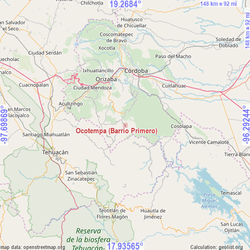
Ocotempa (Barrio Primero) GPS coordinates[2]
18° 36' 11.988" North, 96° 59' 44.016" West
| Map corner | latitude | longitude |
|---|---|---|
| Upper-left | 19.2684°, | -97.69869° |
| Center: | 18.60333°, | -96.99556° |
| Lower-right: | 17.93565°, | -96.29244° |
| Map W x H: | 148.2×148.2 km | = 92.1×92.1mi |
| max Lat: | 32.7° ⇑71.4% North |
| Ocotempa (Barrio Primero): | 18.60333° |
| min Lat: | ⇓28.6% South 14.53588° |
| min Long | Ocotempa (Barri | max Long |
| -117.105° | -96.99556° | -86.73105° |
| W 74.9%⇐ | ⇒25.1% E |
Elevation
Elevation of Ocotempa (Barrio Primero) is 1646 m = 5400 ft, and this is 392.3 m = 1287 ft above average elevation for this country.
| Max E: |
3497 m = 11473 ft | 43.3% |
| Ocotempa (Barrio Primero) | 1646 m 5400 ft | |
| Avg. | 1253.7 m = 4113 ft | |
Min E: |
-1 m = -3 ft | 56.7% |
See also: Mexico elevation on elevation.city.
Geographical zone
Ocotempa (Barrio Primero) is located in North Torrid zone (between Equator and Tropic of Cancer). Distance of this Northern Tropic circle is 537.4 km =333.9 mi to North.| Distance of | km | miles | from Ocotempa (Barrio Primero) |
|---|---|---|---|
| North Pole | 7938.6 | 4932.8 | to North |
| Arctic Circle | 5332.7 | 3313.6 | to North |
| Tropic Cancer | 537.4 | 333.9 | to North |
| Equator | 2068.5 | 1285.3 | to South |


Nearby cities:
15 places around Ocotempa (Barrio Primero): (largest is in red/bold)
• Achichipico
6.7 km =4.2 mi,  184°
184°
• Barrio Cuarto
0.8 km =0.5 mi,  207°
207°
• Barrio Segundo
1.1 km =0.7 mi,  135°
135°
• Barrio Tercero
1.8 km =1.1 mi, 181°
• Los Reyes
9 km =5.6 mi,  326°
326°
• Mixtla de Altamirano
0.9 km =0.6 mi,  161°
161°
• Opotzinga
5.6 km =3.5 mi,  193°
193°
• Tepenacaxtla
9.5 km =5.9 mi,  101°
101°
• Tepetitlanapa
4.8 km =3 mi,  336°
336°
• Tepetlampa
8.4 km =5.2 mi,  131°
131°
• Texhuacán
5.2 km =3.2 mi,  294°
294°
• Tlalca
5.6 km =3.5 mi, 291°
• Xochiojca
8.8 km =5.5 mi,  69°
69°
• Zapaltecatl
8.3 km =5.2 mi,  111°
111°
• Zongolica
7.1 km =4.4 mi,  358°
358°
Sources, notices
• [Note1] Compared only with cities in Mexico existing in our database
• [Src1] Map data: © OpenStreetMap contributors (CC-BY-SA)
• [Src2] Other city data from geonames.org with taken over terms of usage.
• [Src3] Geographical zone / Annual Mean Temperature by Robert A. Rohde @ Wikipedia
