Zongolica geodata
Zongolica (Veracruz) is a seat of a second-order administrative division; located in Mexico in America/Mexico_City (GMT-6) time zone. With population of 6,874 people, there are 1355 cities with bigger population in this country. Compared to other cities in Mexico, 70.6% of cities are located further ↑North; 74.9% of cities are located further ←West and 54.5% of cities have higher elevation than Zongolica. Note1


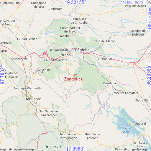
Zongolica GPS coordinates[2]
18° 40' 0.228" North, 96° 59' 49.452" West
| Map corner | latitude | longitude |
|---|---|---|
| Upper-left | 19.33155°, | -97.7002° |
| Center: | 18.66673°, | -96.99707° |
| Lower-right: | 17.9993°, | -96.29395° |
| Map W x H: | 148.1×148.1 km | = 92×92mi |
| max Lat: | 32.7° ⇑70.6% North |
| Zongolica: | 18.66673° |
| min Lat: | ⇓29.4% South 14.53588° |
| min Long | Zongolica | max Long |
| -117.105° | -96.99707° | -86.73105° |
| W 74.9%⇐ | ⇒25.1% E |
Elevation
Elevation of Zongolica is 1219 m = 3999 ft, and this is 34.7 m = 114 ft below average elevation for this country.
| Max E: |
3497 m = 11473 ft | 54.5% |
| Avg. | 1253.7 m = 4113 ft | |
| Zongolica | 1219 m = 3999 ft | |
Min E: |
-1 m = -3 ft | 45.5% |
See also: Mexico elevation on elevation.city.
Geographical zone
Zongolica is located in North Torrid zone (between Equator and Tropic of Cancer). Distance of this Northern Tropic circle is 530.4 km =329.6 mi to North.| Distance of | km | miles | from Zongolica |
|---|---|---|---|
| North Pole | 7931.5 | 4928.4 | to North |
| Arctic Circle | 5325.6 | 3309.2 | to North |
| Tropic Cancer | 530.4 | 329.6 | to North |
| Equator | 2075.5 | 1289.7 | to South |


Nearby cities:
15 places around Zongolica: (largest is in red/bold)
• Atlanca
7.1 km =4.4 mi,  300°
300°
• Barrio Cuarto
7.8 km =4.8 mi,  181°
181°
• Barrio Segundo
7.9 km =4.9 mi,  173°
173°
• Barrio Tercero
8.8 km =5.5 mi, 179°
• Choapa
8.5 km =5.3 mi,  25°
25°
• Los Reyes
4.8 km =3 mi,  275°
275°
• Mixtla de Altamirano
7.9 km =4.9 mi, 176°
• Ocotempa (Barrio Primero)
7.1 km =4.4 mi, 178°
• Oxtotitla
6.5 km =4 mi,  349°
349°
• Poxcautla
8.7 km =5.4 mi,  13°
13°
• Teotzacualco
6.9 km =4.3 mi, 5°
• Tepetitlanapa
3.1 km =1.9 mi,  213°
213°
• Texhuacán
6.7 km =4.2 mi,  222°
222°
• Tlalca
7.1 km =4.4 mi,  225°
225°
• Xibtla
8.1 km =5 mi, 276°
Sources, notices
• [Note1] Compared only with cities in Mexico existing in our database
• [Src1] Map data: © OpenStreetMap contributors (CC-BY-SA)
• [Src2] Other city data from geonames.org with taken over terms of usage.
• [Src3] Geographical zone / Annual Mean Temperature by Robert A. Rohde @ Wikipedia
