Tepetlampa geodata
Tepetlampa (Veracruz) is a populated place; located in Mexico in America/Mexico_City (GMT-6) time zone. With population of 617 people, there are 13976 cities with bigger population in this country. Compared to other cities in Mexico, 71.9% of cities are located further ↑North; 75.7% of cities are located further ←West and 59.3% of cities have higher elevation than Tepetlampa. Note1


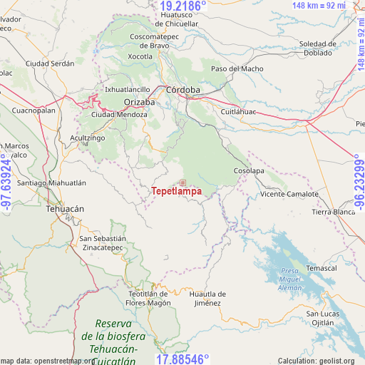
Tepetlampa GPS coordinates[2]
18° 33' 11.988" North, 96° 56' 9.996" West
| Map corner | latitude | longitude |
|---|---|---|
| Upper-left | 19.2186°, | -97.63924° |
| Center: | 18.55333°, | -96.93611° |
| Lower-right: | 17.88546°, | -96.23299° |
| Map W x H: | 148.2×148.2 km | = 92.1×92.1mi |
| max Lat: | 32.7° ⇑71.9% North |
| Tepetlampa: | 18.55333° |
| min Lat: | ⇓28.1% South 14.53588° |
| min Long | Tepetlampa | max Long |
| -117.105° | -96.93611° | -86.73105° |
| W 75.7%⇐ | ⇒24.3% E |
Elevation
Elevation of Tepetlampa is 1036 m = 3399 ft, and this is 217.7 m = 714 ft below average elevation for this country.
| Max E: |
3497 m = 11473 ft | 59.3% |
| Avg. | 1253.7 m = 4113 ft | |
| Tepetlampa | 1036 m = 3399 ft | |
Min E: |
-1 m = -3 ft | 40.7% |
See also: Mexico elevation on elevation.city.
Geographical zone
Tepetlampa is located in North Torrid zone (between Equator and Tropic of Cancer). Distance of this Northern Tropic circle is 543 km =337.4 mi to North.| Distance of | km | miles | from Tepetlampa |
|---|---|---|---|
| North Pole | 7944.1 | 4936.2 | to North |
| Arctic Circle | 5338.2 | 3317 | to North |
| Tropic Cancer | 543 | 337.4 | to North |
| Equator | 2062.9 | 1281.8 | to South |


Nearby cities:
15 places around Tepetlampa: (largest is in red/bold)
• Achichipico
6.9 km =4.3 mi,  260°
260°
• Atexacapa
5.5 km =3.4 mi,  221°
221°
• Barrio Cuarto
8.2 km =5.1 mi,  305°
305°
• Barrio Segundo
7.3 km =4.5 mi, 310°
• Barrio Tercero
7.4 km =4.6 mi,  300°
300°
• Eloxochitlán
6.2 km =3.9 mi,  197°
197°
• Loma Bonita
8.5 km =5.3 mi,  121°
121°
• Mixtla de Altamirano
7.6 km =4.7 mi, 308°
• Ocotempa (Barrio Primero)
8.4 km =5.2 mi, 311°
• Opotzinga
7.6 km =4.7 mi,  270°
270°
• Papaloapan
1.9 km =1.2 mi,  176°
176°
• Tepenacaxtla
4.8 km =3 mi,  39°
39°
• Tepepan
4 km =2.5 mi,  127°
127°
• Xonotipan de Juárez
7.9 km =4.9 mi,  148°
148°
• Zapaltecatl
2.9 km =1.8 mi,  29°
29°
Sources, notices
• [Note1] Compared only with cities in Mexico existing in our database
• [Src1] Map data: © OpenStreetMap contributors (CC-BY-SA)
• [Src2] Other city data from geonames.org with taken over terms of usage.
• [Src3] Geographical zone / Annual Mean Temperature by Robert A. Rohde @ Wikipedia
