Zapaltecatl geodata
Zapaltecatl (Veracruz) is a populated place; located in Mexico in America/Mexico_City (GMT-6) time zone. With population of 555 people, there are 15371 cities with bigger population in this country. Compared to other cities in Mexico, 71.7% of cities are located further ↑North; 75.9% of cities are located further ←West and 60.5% of cities have higher elevation than Zapaltecatl. Note1


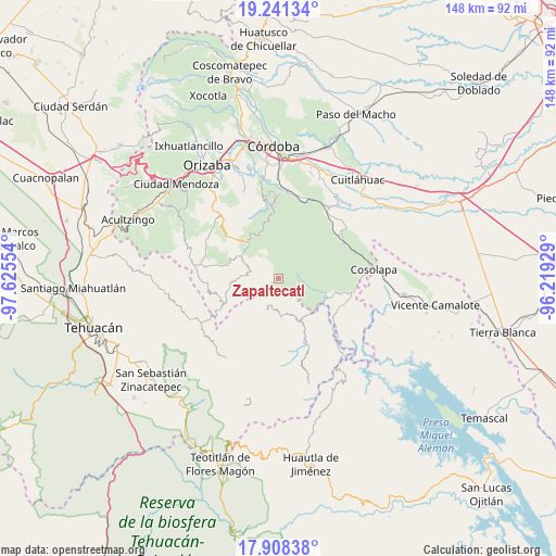
Zapaltecatl GPS coordinates[2]
18° 34' 34.176" North, 96° 55' 20.676" West
| Map corner | latitude | longitude |
|---|---|---|
| Upper-left | 19.24134°, | -97.62554° |
| Center: | 18.57616°, | -96.92241° |
| Lower-right: | 17.90838°, | -96.21929° |
| Map W x H: | 148.2×148.2 km | = 92.1×92.1mi |
| max Lat: | 32.7° ⇑71.7% North |
| Zapaltecatl: | 18.57616° |
| min Lat: | ⇓28.3% South 14.53588° |
| min Long | Zapaltecatl | max Long |
| -117.105° | -96.92241° | -86.73105° |
| W 75.9%⇐ | ⇒24.1% E |
Elevation
Elevation of Zapaltecatl is 966 m = 3169 ft, and this is 287.7 m = 944 ft below average elevation for this country.
| Max E: |
3497 m = 11473 ft | 60.5% |
| Avg. | 1253.7 m = 4113 ft | |
| Zapaltecatl | 966 m = 3169 ft | |
Min E: |
-1 m = -3 ft | 39.5% |
See also: Mexico elevation on elevation.city.
Geographical zone
Zapaltecatl is located in North Torrid zone (between Equator and Tropic of Cancer). Distance of this Northern Tropic circle is 540.4 km =335.8 mi to North.| Distance of | km | miles | from Zapaltecatl |
|---|---|---|---|
| North Pole | 7941.6 | 4934.7 | to North |
| Arctic Circle | 5335.7 | 3315.4 | to North |
| Tropic Cancer | 540.4 | 335.8 | to North |
| Equator | 2065.5 | 1283.4 | to South |


Nearby cities:
15 places around Zapaltecatl: (largest is in red/bold)
• Atexacapa
8.4 km =5.2 mi,  217°
217°
• Barrio Cuarto
8.4 km =5.2 mi,  285°
285°
• Barrio Segundo
7.3 km =4.5 mi, 287°
• Barrio Tercero
7.9 km =4.9 mi,  279°
279°
• El Porvenir
6.3 km =3.9 mi,  24°
24°
• Eloxochitlán
9.1 km =5.7 mi,  201°
201°
• Loma Bonita
9.1 km =5.7 mi,  140°
140°
• Mixtla de Altamirano
7.7 km =4.8 mi, 286°
• Ocotempa (Barrio Primero)
8.3 km =5.2 mi, 291°
• Papaloapan
4.6 km =2.9 mi, 196°
• Tepenacaxtla
2 km =1.2 mi,  53°
53°
• Tepepan
5.3 km =3.3 mi,  160°
160°
• Tepetlampa
2.9 km =1.8 mi,  209°
209°
• Villa Hermosa (Villa Nueva)
9 km =5.6 mi,  67°
67°
• Xochiojca
6.1 km =3.8 mi,  4°
4°
Sources, notices
• [Note1] Compared only with cities in Mexico existing in our database
• [Src1] Map data: © OpenStreetMap contributors (CC-BY-SA)
• [Src2] Other city data from geonames.org with taken over terms of usage.
• [Src3] Geographical zone / Annual Mean Temperature by Robert A. Rohde @ Wikipedia
