Yoricostio (La Villita) geodata
Yoricostio (La Villita) (Michoacán) is a populated place; located in Mexico in America/Mexico_City (GMT-6) time zone. With population of 972 people, there are 8937 cities with bigger population in this country. Compared to other cities in Mexico, 57.8% of cities are located further ↑North; 76.6% of cities are located further →East and 85.9% of cities have lower elevation than Yoricostio (La Villita). Note1
Current local time in Yoricostio (La Villita):
12:54 AM, WednesdayDifference from your time zone: hours


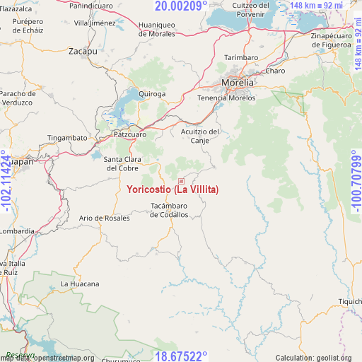
Yoricostio (La Villita) GPS coordinates[2]
19° 20' 24" North, 101° 24' 39.996" West
| Map corner | latitude | longitude |
|---|---|---|
| Upper-left | 20.00209°, | -102.11424° |
| Center: | 19.34°, | -101.41111° |
| Lower-right: | 18.67522°, | -100.70799° |
| Map W x H: | 147.5×147.5 km | = 91.7×91.7mi |
| max Lat: | 32.7° ⇑57.8% North |
| Yoricostio (La Villita): | 19.34° |
| min Lat: | ⇓42.2% South 14.53588° |
| min Long | Yoricostio (La | max Long |
| -117.105° | -101.41111° | -86.73105° |
| W 23.4%⇐ | ⇒76.6% E |
Elevation
Elevation of Yoricostio (La Villita) is 2278 m = 7474 ft, and this is 1024.3 m = 3361 ft above average elevation for this country.
| Max E: |
3497 m = 11473 ft | 14.1% |
| Yoricostio (La Villita) | 2278 m 7474 ft | |
| Avg. | 1253.7 m = 4113 ft | |
Min E: |
-1 m = -3 ft | 85.9% |
See also: Mexico elevation on elevation.city.
Geographical zone
Yoricostio (La Villita) is located in North Torrid zone (between Equator and Tropic of Cancer). Distance of this Northern Tropic circle is 455.5 km =283 mi to North.| Distance of | km | miles | from Yoricostio (La Villita) |
|---|---|---|---|
| North Pole | 7856.7 | 4881.9 | to North |
| Arctic Circle | 5250.8 | 3262.7 | to North |
| Tropic Cancer | 455.5 | 283 | to North |
| Equator | 2150.4 | 1336.2 | to South |


Nearby cities:
15 places around Yoricostio (La Villita): (largest is in red/bold)
• Canícuaro
12.3 km =7.6 mi,  192°
192°
• Cutzaro
14.4 km =8.9 mi,  33°
33°
• Cópitero
4.4 km =2.7 mi,  145°
145°
• La Viña
10.3 km =6.4 mi,  216°
216°
• Las Hoyas Altas
12 km =7.5 mi, 185°
• Las Joyas (El Poblado)
15.1 km =9.4 mi, 188°
• San Gregorio
15.1 km =9.4 mi,  297°
297°
• San José de los Laureles
5.2 km =3.2 mi,  265°
265°
• San Juan de Viña
7.1 km =4.4 mi, 273°
• San Miguel Tamácuaro
11.1 km =6.9 mi, 194°
• Santas Marías
15.1 km =9.4 mi,  232°
232°
• Serrano
12.3 km =7.6 mi,  235°
235°
• Tacámbaro de Codallos
12.7 km =7.9 mi,  202°
202°
• Testerazo
11.6 km =7.2 mi,  205°
205°
• Villa Madero
15 km =9.3 mi,  67°
67°
Sources, notices
• [Note1] Compared only with cities in Mexico existing in our database
• [Src1] Map data: © OpenStreetMap contributors (CC-BY-SA)
• [Src2] Other city data from geonames.org with taken over terms of usage.
• [Src3] Geographical zone / Annual Mean Temperature by Robert A. Rohde @ Wikipedia
