Las Limas geodata
Las Limas (Chiapas) is a populated place; located in Mexico in America/Mexico_City (GMT-6) time zone. With population of 695 people, there are 12521 cities with bigger population in this country. Compared to other cities in Mexico, 87.7% of cities are located further ↑North; 90.5% of cities are located further ←West and 61% of cities have higher elevation than Las Limas. Note1


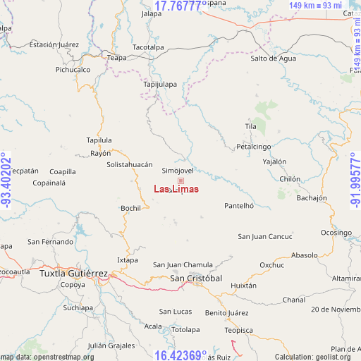
Las Limas GPS coordinates[2]
17° 5' 48.984" North, 92° 41' 56.004" West
| Map corner | latitude | longitude |
|---|---|---|
| Upper-left | 17.76777°, | -93.40202° |
| Center: | 17.09694°, | -92.69889° |
| Lower-right: | 16.42369°, | -91.99577° |
| Map W x H: | 149.4×149.5 km | = 92.8×92.9mi |
| max Lat: | 32.7° ⇑87.7% North |
| Las Limas: | 17.09694° |
| min Lat: | ⇓12.3% South 14.53588° |
| min Long | Las Limas | max Long |
| -117.105° | -92.69889° | -86.73105° |
| W 90.5%⇐ | ⇒9.5% E |
Elevation
Elevation of Las Limas is 938 m = 3077 ft, and this is 315.7 m = 1036 ft below average elevation for this country.
| Max E: |
3497 m = 11473 ft | 61% |
| Avg. | 1253.7 m = 4113 ft | |
| Las Limas | 938 m = 3077 ft | |
Min E: |
-1 m = -3 ft | 39% |
See also: Mexico elevation on elevation.city.
Geographical zone
Las Limas is located in North Torrid zone (between Equator and Tropic of Cancer). Distance of this Northern Tropic circle is 704.9 km =438 mi to North.| Distance of | km | miles | from Las Limas |
|---|---|---|---|
| North Pole | 8106.1 | 5036.9 | to North |
| Arctic Circle | 5500.2 | 3417.7 | to North |
| Tropic Cancer | 704.9 | 438 | to North |
| Equator | 1901 | 1181.2 | to South |


Nearby cities:
15 places around Las Limas: (largest is in red/bold)
• Chabajebal
5.7 km =3.5 mi,  164°
164°
• Concepción el Amparo
8.3 km =5.2 mi,  105°
105°
• Cálido
9.4 km =5.8 mi,  271°
271°
• El Bosque
4.5 km =2.8 mi,  212°
212°
• Huitiupán
8.5 km =5.3 mi,  9°
9°
• Jolitontic
8.4 km =5.2 mi,  130°
130°
• Joltealal
8.5 km =5.3 mi, 105°
• La Pimienta
8.3 km =5.2 mi,  306°
306°
• Los Ángeles
8.1 km =5 mi,  223°
223°
• Natividad Pechuag
8.7 km =5.4 mi,  82°
82°
• Rivera Galeana
9.5 km =5.9 mi,  289°
289°
• Saclum
10.1 km =6.3 mi,  97°
97°
• San Pedro Nichtalucum
7.6 km =4.7 mi,  203°
203°
• Simojovel de Allende
5.1 km =3.2 mi,  341°
341°
• Yuquín
4.6 km =2.9 mi, 269°
Sources, notices
• [Note1] Compared only with cities in Mexico existing in our database
• [Src1] Map data: © OpenStreetMap contributors (CC-BY-SA)
• [Src2] Other city data from geonames.org with taken over terms of usage.
• [Src3] Geographical zone / Annual Mean Temperature by Robert A. Rohde @ Wikipedia
