Cambil geodata
Cambil (Chiapas) is a populated place; located in Mexico in America/Mexico_City (GMT-6) time zone. With population of 706 people, there are 12320 cities with bigger population in this country. Compared to other cities in Mexico, 98.7% of cities are located further ↑North; 93.2% of cities are located further ←West and 95.7% of cities have lower elevation than Cambil. Note1


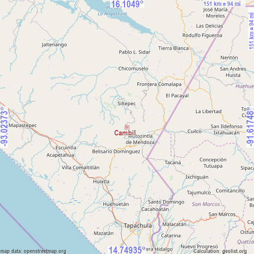
Cambil GPS coordinates[2]
15° 25' 41.628" North, 92° 19' 14.16" West
| Map corner | latitude | longitude |
|---|---|---|
| Upper-left | 16.1049°, | -93.02373° |
| Center: | 15.42823°, | -92.3206° |
| Lower-right: | 14.74935°, | -91.61748° |
| Map W x H: | 150.7×150.7 km | = 93.6×93.6mi |
| max Lat: | 32.7° ⇑98.7% North |
| Cambil: | 15.42823° |
| min Lat: | ⇓1.3% South 14.53588° |
| min Long | Cambil | max Long |
| -117.105° | -92.3206° | -86.73105° |
| W 93.2%⇐ | ⇒6.8% E |
Elevation
Elevation of Cambil is 2615 m = 8579 ft, and this is 1361.3 m = 4466 ft above average elevation for this country.
| Max E: |
3497 m = 11473 ft | 4.3% |
| Cambil | 2615 m 8579 ft | |
| Avg. | 1253.7 m = 4113 ft | |
Min E: |
-1 m = -3 ft | 95.7% |
See also: Mexico elevation on elevation.city.
Geographical zone
Cambil is located in North Torrid zone (between Equator and Tropic of Cancer). Distance of this Northern Tropic circle is 890.5 km =553.3 mi to North.| Distance of | km | miles | from Cambil |
|---|---|---|---|
| North Pole | 8291.6 | 5152.2 | to North |
| Arctic Circle | 5685.7 | 3532.9 | to North |
| Tropic Cancer | 890.5 | 553.3 | to North |
| Equator | 1715.5 | 1066 | to South |


Nearby cities:
15 places around Cambil: (largest is in red/bold)
• Benito Juárez
6.9 km =4.3 mi,  173°
173°
• Canadá
10.3 km =6.4 mi,  77°
77°
• El Carrizal
3.4 km =2.1 mi,  140°
140°
• El Palmar Grande
10.5 km =6.5 mi,  41°
41°
• El Porvenir de Velasco Suárez
5.4 km =3.4 mi,  53°
53°
• El Rodeo
7.3 km =4.5 mi, 44°
• Las Pilas
7.4 km =4.6 mi,  65°
65°
• Las Salvias
3.2 km =2 mi,  31°
31°
• Malé
8.1 km =5 mi, 72°
• Motozintla
10.5 km =6.5 mi,  130°
130°
• Nueva Esperanza Uno
8.4 km =5.2 mi, 79°
• San José Ixtepec
10.4 km =6.5 mi,  215°
215°
• Santo Domingo (La Cascada)
11.1 km =6.9 mi,  305°
305°
• Toquián Grande
11.9 km =7.4 mi,  342°
342°
• Vega del Rosario
10.4 km =6.5 mi,  7°
7°
Sources, notices
• [Note1] Compared only with cities in Mexico existing in our database
• [Src1] Map data: © OpenStreetMap contributors (CC-BY-SA)
• [Src2] Other city data from geonames.org with taken over terms of usage.
• [Src3] Geographical zone / Annual Mean Temperature by Robert A. Rohde @ Wikipedia
