Los Palacios geodata
Los Palacios (Chiapas) is a populated place; located in Mexico in America/Mexico_City (GMT-6) time zone. With population of 1,217 people, there are 7142 cities with bigger population in this country. Compared to other cities in Mexico, 99.8% of cities are located further ↑North; 93.7% of cities are located further ←West and 80.4% of cities have higher elevation than Los Palacios. Note1


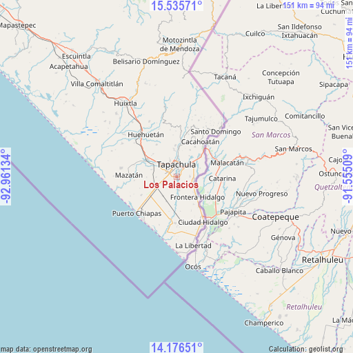
Los Palacios GPS coordinates[2]
14° 51' 25.848" North, 92° 15' 29.556" West
| Map corner | latitude | longitude |
|---|---|---|
| Upper-left | 15.53571°, | -92.96134° |
| Center: | 14.85718°, | -92.25821° |
| Lower-right: | 14.17651°, | -91.55509° |
| Map W x H: | 151.1×151.1 km | = 93.9×93.9mi |
| max Lat: | 32.7° ⇑99.8% North |
| Los Palacios: | 14.85718° |
| min Lat: | ⇓0.2% South 14.53588° |
| min Long | Los Palacios | max Long |
| -117.105° | -92.25821° | -86.73105° |
| W 93.7%⇐ | ⇒6.3% E |
Elevation
Elevation of Los Palacios is 89 m = 292 ft, and this is 1164.7 m = 3821 ft below average elevation for this country.
| Max E: |
3497 m = 11473 ft | 80.4% |
| Avg. | 1253.7 m = 4113 ft | |
| Los Palacios | 89 m = 292 ft | |
Min E: |
-1 m = -3 ft | 19.6% |
See also: Mexico elevation on elevation.city.
Geographical zone
Los Palacios is located in North Torrid zone (between Equator and Tropic of Cancer). Distance of this Northern Tropic circle is 954 km =592.8 mi to North.| Distance of | km | miles | from Los Palacios |
|---|---|---|---|
| North Pole | 8355.1 | 5191.6 | to North |
| Arctic Circle | 5749.2 | 3572.4 | to North |
| Tropic Cancer | 954 | 592.8 | to North |
| Equator | 1652 | 1026.5 | to South |


Nearby cities:
15 places around Los Palacios: (largest is in red/bold)
• Cebadilla 1ra. Sección
2.4 km =1.5 mi,  287°
287°
• El Sacrificio
3.7 km =2.3 mi,  61°
61°
• Guadalupe Victoria
6 km =3.7 mi,  172°
172°
• La Joya
0.8 km =0.5 mi,  16°
16°
• Las Palmeras
2.2 km =1.4 mi,  300°
300°
• Llano de la Lima
4.3 km =2.7 mi,  283°
283°
• Los Cafetales
4.8 km =3 mi, 283°
• Los Encinos
3.6 km =2.2 mi,  37°
37°
• Murillo
6 km =3.7 mi,  220°
220°
• Octavio Paz
0.6 km =0.4 mi, 276°
• Omoa
3.8 km =2.4 mi,  134°
134°
• Raymundo Enríquez
6.2 km =3.9 mi, 280°
• Tapachula
5.2 km =3.2 mi,  0°
0°
• Vicente Guerrero
5.6 km =3.5 mi,  90°
90°
• Vida Mejor I
5.5 km =3.4 mi, 284°
Sources, notices
• [Note1] Compared only with cities in Mexico existing in our database
• [Src1] Map data: © OpenStreetMap contributors (CC-BY-SA)
• [Src2] Other city data from geonames.org with taken over terms of usage.
• [Src3] Geographical zone / Annual Mean Temperature by Robert A. Rohde @ Wikipedia
