La Selva Natividad geodata
La Selva Natividad (Chiapas) is a populated place; located in Mexico in America/Mexico_City (GMT-6) time zone. With population of 699 people, there are 12460 cities with bigger population in this country. Compared to other cities in Mexico, 92.2% of cities are located further ↑North; 90.6% of cities are located further ←West and 92% of cities have lower elevation than La Selva Natividad. Note1


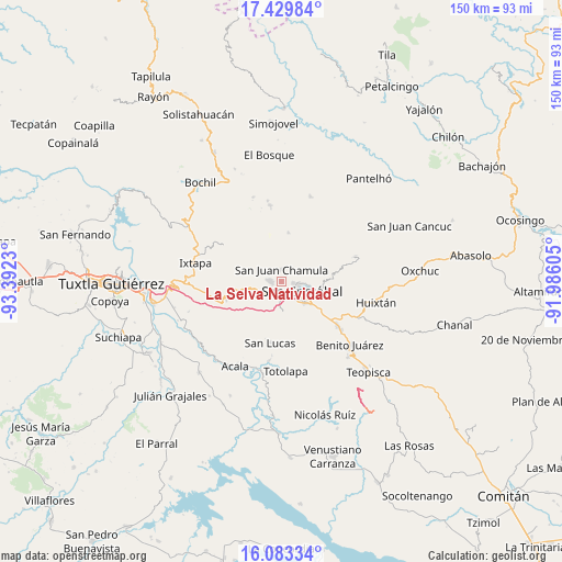
La Selva Natividad GPS coordinates[2]
16° 45' 28.008" North, 92° 41' 21.012" West
| Map corner | latitude | longitude |
|---|---|---|
| Upper-left | 17.42984°, | -93.3923° |
| Center: | 16.75778°, | -92.68917° |
| Lower-right: | 16.08334°, | -91.98605° |
| Map W x H: | 149.7×149.7 km | = 93×93mi |
| max Lat: | 32.7° ⇑92.2% North |
| La Selva Natividad: | 16.75778° |
| min Lat: | ⇓7.8% South 14.53588° |
| min Long | La Selva Nativi | max Long |
| -117.105° | -92.68917° | -86.73105° |
| W 90.6%⇐ | ⇒9.4% E |
Elevation
Elevation of La Selva Natividad is 2486 m = 8156 ft, and this is 1232.3 m = 4043 ft above average elevation for this country.
| Max E: |
3497 m = 11473 ft | 8% |
| La Selva Natividad | 2486 m 8156 ft | |
| Avg. | 1253.7 m = 4113 ft | |
Min E: |
-1 m = -3 ft | 92% |
See also: Mexico elevation on elevation.city.
Geographical zone
La Selva Natividad is located in North Torrid zone (between Equator and Tropic of Cancer). Distance of this Northern Tropic circle is 742.6 km =461.4 mi to North.| Distance of | km | miles | from La Selva Natividad |
|---|---|---|---|
| North Pole | 8143.8 | 5060.3 | to North |
| Arctic Circle | 5537.9 | 3441.1 | to North |
| Tropic Cancer | 742.6 | 461.4 | to North |
| Equator | 1863.3 | 1157.8 | to South |


Nearby cities:
15 places around La Selva Natividad: (largest is in red/bold)
• Arvenza Uno
4.1 km =2.5 mi,  306°
306°
• Bahosil
4.7 km =2.9 mi,  300°
300°
• Bechijtic
2 km =1.2 mi,  342°
342°
• Bochojbo Alto
3.8 km =2.4 mi,  230°
230°
• Chamula
2.9 km =1.8 mi,  359°
359°
• Cuchulumtic
2.7 km =1.7 mi,  323°
323°
• Ichintón
0.9 km =0.6 mi,  58°
58°
• Jechtoch
4.8 km =3 mi,  220°
220°
• La Ventana
1.1 km =0.7 mi, 323°
• Laguna Petej
4.2 km =2.6 mi,  32°
32°
• Milpoleta
3.4 km =2.1 mi, 61°
• Nachig
4.9 km =3 mi, 231°
• Nichén
4.9 km =3 mi,  6°
6°
• San Antonio del Monte
3.9 km =2.4 mi,  85°
85°
• Zinacantán
3.6 km =2.2 mi,  274°
274°
Sources, notices
• [Note1] Compared only with cities in Mexico existing in our database
• [Src1] Map data: © OpenStreetMap contributors (CC-BY-SA)
• [Src2] Other city data from geonames.org with taken over terms of usage.
• [Src3] Geographical zone / Annual Mean Temperature by Robert A. Rohde @ Wikipedia
