El Jicote geodata
El Jicote (Nayarit) is a populated place; located in Mexico in America/Mazatlan (GMT-7) time zone. With population of 1,882 people, there are 4619 cities with bigger population in this country. Compared to other cities in Mexico, 82.6% of cities are located further ↓South; 92% of cities are located further →East and 75.7% of cities have higher elevation than El Jicote. Note1


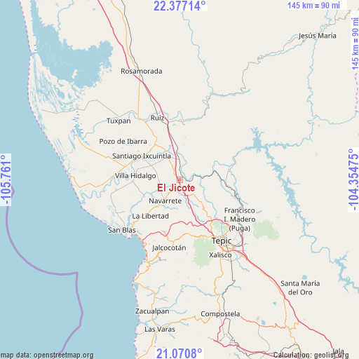
El Jicote GPS coordinates[2]
21° 43' 31.62" North, 105° 3' 28.332" West
| Map corner | latitude | longitude |
|---|---|---|
| Upper-left | 22.37714°, | -105.761° |
| Center: | 21.72545°, | -105.05787° |
| Lower-right: | 21.0708°, | -104.35475° |
| Map W x H: | 145.3×145.3 km | = 90.3×90.3mi |
| max Lat: | 32.7° ⇑17.4% North |
| El Jicote: | 21.72545° |
| min Lat: | ⇓82.6% South 14.53588° |
| min Long | El Jicote | max Long |
| -117.105° | -105.05787° | -86.73105° |
| W 8%⇐ | ⇒92% E |
Elevation
Elevation of El Jicote is 198 m = 650 ft, and this is 1055.7 m = 3464 ft below average elevation for this country.
| Max E: |
3497 m = 11473 ft | 75.7% |
| Avg. | 1253.7 m = 4113 ft | |
| El Jicote | 198 m = 650 ft | |
Min E: |
-1 m = -3 ft | 24.3% |
See also: Mexico elevation on elevation.city.
Geographical zone
El Jicote is located in North Torrid zone (between Equator and Tropic of Cancer). Distance of this Northern Tropic circle is 190.3 km =118.2 mi to North.| Distance of | km | miles | from El Jicote |
|---|---|---|---|
| North Pole | 7591.4 | 4717.1 | to North |
| Arctic Circle | 4985.5 | 3097.8 | to North |
| Tropic Cancer | 190.3 | 118.2 | to North |
| Equator | 2415.6 | 1501 | to South |


Nearby cities:
15 places around El Jicote: (largest is in red/bold)
• Cinco de Mayo
4.9 km =3 mi,  218°
218°
• El Capomal
14.3 km =8.9 mi,  332°
332°
• El Tambor
3.4 km =2.1 mi,  44°
44°
• El Tizate
10.4 km =6.5 mi,  324°
324°
• Estación Nanchi (Peñasquillo)
8.2 km =5.1 mi,  355°
355°
• Huaristemba
12.6 km =7.8 mi,  234°
234°
• Leandro B. Flores
13.1 km =8.1 mi,  295°
295°
• Mojarritas
3.1 km =1.9 mi, 356°
• Navarrete
10.4 km =6.5 mi,  214°
214°
• Puerta Azul
16.4 km =10.2 mi,  314°
314°
• Reforma Agraria
16 km =9.9 mi,  243°
243°
• Sauta
8.8 km =5.5 mi,  266°
266°
• Vado del Cora (Estación Pani)
5.5 km =3.4 mi,  76°
76°
• Valle Lerma
10.7 km =6.6 mi, 334°
• Yago
12.3 km =7.6 mi, 356°
Sources, notices
• [Note1] Compared only with cities in Mexico existing in our database
• [Src1] Map data: © OpenStreetMap contributors (CC-BY-SA)
• [Src2] Other city data from geonames.org with taken over terms of usage.
• [Src3] Geographical zone / Annual Mean Temperature by Robert A. Rohde @ Wikipedia
