Santiago Ixcuintla geodata
Santiago Ixcuintla (Nayarit) is a seat of a second-order administrative division; located in Mexico in America/Mazatlan (GMT-7) time zone. With population of 18,241 people, there are 535 cities with bigger population in this country. Compared to other cities in Mexico, 83% of cities are located further ↓South; 92.4% of cities are located further →East and 92.5% of cities have higher elevation than Santiago Ixcuintla. Note1


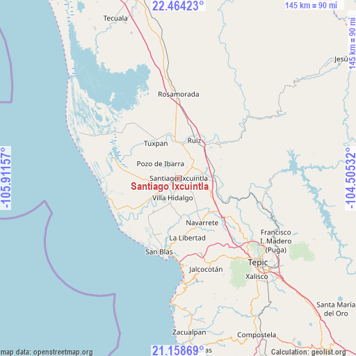
Santiago Ixcuintla GPS coordinates[2]
21° 48' 46.62" North, 105° 12' 30.384" West
| Map corner | latitude | longitude |
|---|---|---|
| Upper-left | 22.46423°, | -105.91157° |
| Center: | 21.81295°, | -105.20844° |
| Lower-right: | 21.15869°, | -104.50532° |
| Map W x H: | 145.2×145.2 km | = 90.2×90.2mi |
| max Lat: | 32.7° ⇑17% North |
| Santiago Ixcuintla: | 21.81295° |
| min Lat: | ⇓83% South 14.53588° |
| min Long | Santiago Ixcuin | max Long |
| -117.105° | -105.20844° | -86.73105° |
| W 7.6%⇐ | ⇒92.4% E |
Elevation
Elevation of Santiago Ixcuintla is 18 m = 59 ft, and this is 1235.7 m = 4054 ft below average elevation for this country.
| Max E: |
3497 m = 11473 ft | 92.5% |
| Avg. | 1253.7 m = 4113 ft | |
| Santiago Ixcuintla | 18 m = 59 ft | |
Min E: |
-1 m = -3 ft | 7.5% |
See also: Mexico elevation on elevation.city.
Geographical zone
Santiago Ixcuintla is located in North Torrid zone (between Equator and Tropic of Cancer). Distance of this Northern Tropic circle is 180.5 km =112.2 mi to North.| Distance of | km | miles | from Santiago Ixcuintla |
|---|---|---|---|
| North Pole | 7581.7 | 4711 | to North |
| Arctic Circle | 4975.8 | 3091.8 | to North |
| Tropic Cancer | 180.5 | 112.2 | to North |
| Equator | 2425.4 | 1507.1 | to South |


Nearby cities:
15 places around Santiago Ixcuintla: (largest is in red/bold)
• Amapa
5.8 km =3.6 mi,  235°
235°
• Cerritos
7.4 km =4.6 mi, 241°
• Colonia Emiliano Zapata
2.1 km =1.3 mi,  326°
326°
• El Capomal
9.5 km =5.9 mi,  71°
71°
• El Puente
5.7 km =3.5 mi,  316°
316°
• El Tizate
9.6 km =6 mi,  97°
97°
• Gavilán Grande
8.9 km =5.5 mi,  259°
259°
• La Presa
1.6 km =1 mi,  152°
152°
• Leandro B. Flores
5.6 km =3.5 mi,  137°
137°
• Paredones (La Punta de la Laguna)
6.5 km =4 mi,  0°
0°
• Pozo de Ibarra
9.5 km =5.9 mi,  309°
309°
• Pozo de Villa
10.2 km =6.3 mi,  282°
282°
• Puerta Azul
4.3 km =2.7 mi,  64°
64°
• Valle Morelos
8.3 km =5.2 mi,  292°
292°
• Villa Hidalgo
8.2 km =5.1 mi,  196°
196°
Sources, notices
• [Note1] Compared only with cities in Mexico existing in our database
• [Src1] Map data: © OpenStreetMap contributors (CC-BY-SA)
• [Src2] Other city data from geonames.org with taken over terms of usage.
• [Src3] Geographical zone / Annual Mean Temperature by Robert A. Rohde @ Wikipedia
