Leandro B. Flores geodata
Leandro B. Flores (Nayarit) is a populated place; located in Mexico in America/Mazatlan (GMT-7) time zone. With population of 549 people, there are 15509 cities with bigger population in this country. Compared to other cities in Mexico, 82.8% of cities are located further ↓South; 92.3% of cities are located further →East and 92.5% of cities have higher elevation than Leandro B. Flores. Note1


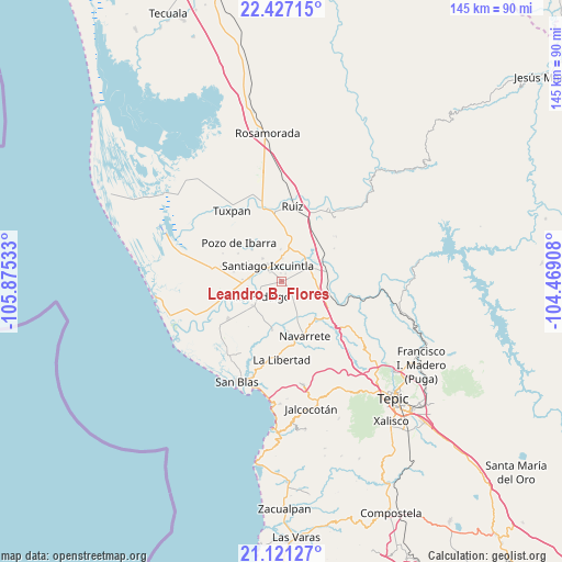
Leandro B. Flores GPS coordinates[2]
21° 46' 32.52" North, 105° 10' 19.92" West
| Map corner | latitude | longitude |
|---|---|---|
| Upper-left | 22.42715°, | -105.87533° |
| Center: | 21.7757°, | -105.1722° |
| Lower-right: | 21.12127°, | -104.46908° |
| Map W x H: | 145.2×145.2 km | = 90.2×90.2mi |
| max Lat: | 32.7° ⇑17.2% North |
| Leandro B. Flores: | 21.7757° |
| min Lat: | ⇓82.8% South 14.53588° |
| min Long | Leandro B. Flor | max Long |
| -117.105° | -105.1722° | -86.73105° |
| W 7.7%⇐ | ⇒92.3% E |
Elevation
Elevation of Leandro B. Flores is 18 m = 59 ft, and this is 1235.7 m = 4054 ft below average elevation for this country.
| Max E: |
3497 m = 11473 ft | 92.5% |
| Avg. | 1253.7 m = 4113 ft | |
| Leandro B. Flores | 18 m = 59 ft | |
Min E: |
-1 m = -3 ft | 7.5% |
See also: Mexico elevation on elevation.city.
Geographical zone
Leandro B. Flores is located in North Torrid zone (between Equator and Tropic of Cancer). Distance of this Northern Tropic circle is 184.7 km =114.8 mi to North.| Distance of | km | miles | from Leandro B. Flores |
|---|---|---|---|
| North Pole | 7585.8 | 4713.6 | to North |
| Arctic Circle | 4979.9 | 3094.4 | to North |
| Tropic Cancer | 184.7 | 114.8 | to North |
| Equator | 2421.2 | 1504.5 | to South |


Nearby cities:
15 places around Leandro B. Flores: (largest is in red/bold)
• Amapa
8.6 km =5.3 mi,  275°
275°
• Cerritos
10.3 km =6.4 mi,  273°
273°
• Colonia Emiliano Zapata
7.7 km =4.8 mi,  320°
320°
• El Capomal
8.8 km =5.5 mi,  36°
36°
• El Corte
9.7 km =6 mi,  230°
230°
• El Puente
11.3 km =7 mi, 317°
• El Tizate
6.4 km =4 mi,  63°
63°
• Estación Nanchi (Peñasquillo)
11.5 km =7.1 mi,  76°
76°
• La Presa
4.1 km =2.5 mi,  312°
312°
• Paredones (La Punta de la Laguna)
11.3 km =7 mi,  340°
340°
• Puerta Azul
6 km =3.7 mi,  1°
1°
• Santiago Ixcuintla
5.6 km =3.5 mi, 317°
• Sauta
6.8 km =4.2 mi,  153°
153°
• Valle Lerma
8.2 km =5.1 mi, 60°
• Villa Hidalgo
7.1 km =4.4 mi,  238°
238°
Sources, notices
• [Note1] Compared only with cities in Mexico existing in our database
• [Src1] Map data: © OpenStreetMap contributors (CC-BY-SA)
• [Src2] Other city data from geonames.org with taken over terms of usage.
• [Src3] Geographical zone / Annual Mean Temperature by Robert A. Rohde @ Wikipedia
