Sauta geodata
Sauta (Nayarit) is a populated place; located in Mexico in America/Mazatlan (GMT-7) time zone. With population of 2,220 people, there are 3955 cities with bigger population in this country. Compared to other cities in Mexico, 82.6% of cities are located further ↓South; 92.1% of cities are located further →East and 85.7% of cities have higher elevation than Sauta. Note1


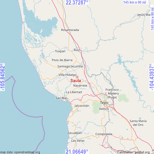
Sauta GPS coordinates[2]
21° 43' 16.176" North, 105° 8' 32.964" West
| Map corner | latitude | longitude |
|---|---|---|
| Upper-left | 22.37287°, | -105.84562° |
| Center: | 21.72116°, | -105.14249° |
| Lower-right: | 21.06649°, | -104.43937° |
| Map W x H: | 145.3×145.3 km | = 90.3×90.3mi |
| max Lat: | 32.7° ⇑17.4% North |
| Sauta: | 21.72116° |
| min Lat: | ⇓82.6% South 14.53588° |
| min Long | Sauta | max Long |
| -117.105° | -105.14249° | -86.73105° |
| W 7.9%⇐ | ⇒92.1% E |
Elevation
Elevation of Sauta is 40 m = 131 ft, and this is 1213.7 m = 3982 ft below average elevation for this country.
| Max E: |
3497 m = 11473 ft | 85.7% |
| Avg. | 1253.7 m = 4113 ft | |
| Sauta | 40 m = 131 ft | |
Min E: |
-1 m = -3 ft | 14.3% |
See also: Mexico elevation on elevation.city.
Geographical zone
Sauta is located in North Torrid zone (between Equator and Tropic of Cancer). Distance of this Northern Tropic circle is 190.8 km =118.6 mi to North.| Distance of | km | miles | from Sauta |
|---|---|---|---|
| North Pole | 7591.9 | 4717.4 | to North |
| Arctic Circle | 4986 | 3098.2 | to North |
| Tropic Cancer | 190.8 | 118.6 | to North |
| Equator | 2415.2 | 1500.7 | to South |


Nearby cities:
15 places around Sauta: (largest is in red/bold)
• Cinco de Mayo
6.6 km =4.1 mi,  120°
120°
• El Corte
10.6 km =6.6 mi,  269°
269°
• El Jicote
8.8 km =5.5 mi,  86°
86°
• El Tambor
11.5 km =7.1 mi,  75°
75°
• El Tizate
9.4 km =5.8 mi,  16°
16°
• Estación Nanchi (Peñasquillo)
11.9 km =7.4 mi,  42°
42°
• Huaristemba
7 km =4.3 mi,  192°
192°
• La Presa
10.7 km =6.6 mi,  325°
325°
• Leandro B. Flores
6.8 km =4.2 mi, 333°
• Mojarritas
9.2 km =5.7 mi,  67°
67°
• Navarrete
8.6 km =5.3 mi,  160°
160°
• Reforma Agraria
8.6 km =5.3 mi,  220°
220°
• Santiago Ixcuintla
12.3 km =7.6 mi, 326°
• Valle Lerma
10.9 km =6.8 mi, 21°
• Villa Hidalgo
9.4 km =5.8 mi,  284°
284°
Sources, notices
• [Note1] Compared only with cities in Mexico existing in our database
• [Src1] Map data: © OpenStreetMap contributors (CC-BY-SA)
• [Src2] Other city data from geonames.org with taken over terms of usage.
• [Src3] Geographical zone / Annual Mean Temperature by Robert A. Rohde @ Wikipedia
