Epeche Chico (Penche Chico) geodata
Epeche Chico (Penche Chico) (Jalisco) is a populated place; located in Mexico in America/Mexico_City (GMT-6) time zone. With population of 724 people, there are 12063 cities with bigger population in this country. Compared to other cities in Mexico, 55.8% of cities are located further ↓South; 85.8% of cities are located further →East and 79.9% of cities have lower elevation than Epeche Chico (Penche Chico). Note1
Current local time in Epeche Chico (Penche Chico):
05:27 AM, WednesdayDifference from your time zone: hours


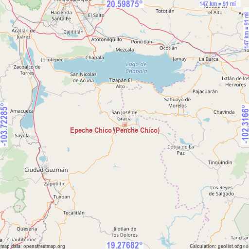
Epeche Chico (Penche Chico) GPS coordinates[2]
19° 56' 21.012" North, 103° 1' 10.992" West
| Map corner | latitude | longitude |
|---|---|---|
| Upper-left | 20.59875°, | -103.72285° |
| Center: | 19.93917°, | -103.01972° |
| Lower-right: | 19.27682°, | -102.3166° |
| Map W x H: | 147×147 km | = 91.3×91.3mi |
| max Lat: | 32.7° ⇑44.2% North |
| Epeche Chico (Penche Chico): | 19.93917° |
| min Lat: | ⇓55.8% South 14.53588° |
| min Long | Epeche Chico (P | max Long |
| -117.105° | -103.01972° | -86.73105° |
| W 14.2%⇐ | ⇒85.8% E |
Elevation
Elevation of Epeche Chico (Penche Chico) is 2139 m = 7018 ft, and this is 885.3 m = 2905 ft above average elevation for this country.
| Max E: |
3497 m = 11473 ft | 20.1% |
| Epeche Chico (Penche Chico) | 2139 m 7018 ft | |
| Avg. | 1253.7 m = 4113 ft | |
Min E: |
-1 m = -3 ft | 79.9% |
See also: Mexico elevation on elevation.city.
Geographical zone
Epeche Chico (Penche Chico) is located in North Torrid zone (between Equator and Tropic of Cancer). Distance of this Northern Tropic circle is 388.9 km =241.7 mi to North.| Distance of | km | miles | from Epeche Chico (Penche Chico) |
|---|---|---|---|
| North Pole | 7790 | 4840.5 | to North |
| Arctic Circle | 5184.1 | 3221.2 | to North |
| Tropic Cancer | 388.9 | 241.7 | to North |
| Equator | 2217 | 1377.6 | to South |


Nearby cities:
15 places around Epeche Chico (Penche Chico): (largest is in red/bold)
• Abadiano (Los Bajos)
17.8 km =11.1 mi,  68°
68°
• El Sabino
10.6 km =6.6 mi,  49°
49°
• El Volantín
15.7 km =9.8 mi,  325°
325°
• La Garita
21.2 km =13.2 mi,  210°
210°
• La Manzanilla de la Paz
15.9 km =9.9 mi,  297°
297°
• Lázaro Cárdenas
20.4 km =12.7 mi,  105°
105°
• Mazamitla
2.6 km =1.6 mi,  181°
181°
• Ojo de Rana
18 km =11.2 mi, 47°
• Paso de Piedra
8.2 km =5.1 mi,  58°
58°
• Quitupan
15.4 km =9.6 mi,  94°
94°
• San José de Gracia
5.6 km =3.5 mi,  357°
357°
• Tizapán el Alto
24.8 km =15.4 mi,  354°
354°
• Valle de Juárez
8 km =5 mi,  95°
95°
• Villa Emiliano Zapata
25.5 km =15.8 mi,  6°
6°
• Villa Morelos
18.6 km =11.6 mi,  314°
314°
Sources, notices
• [Note1] Compared only with cities in Mexico existing in our database
• [Src1] Map data: © OpenStreetMap contributors (CC-BY-SA)
• [Src2] Other city data from geonames.org with taken over terms of usage.
• [Src3] Geographical zone / Annual Mean Temperature by Robert A. Rohde @ Wikipedia
