La Manzanilla de la Paz geodata
La Manzanilla de la Paz (Jalisco) is a seat of a second-order administrative division; located in Mexico in America/Mexico_City (GMT-6) time zone. With population of 2,549 people, there are 3475 cities with bigger population in this country. Compared to other cities in Mexico, 57.1% of cities are located further ↓South; 86.4% of cities are located further →East and 76.5% of cities have lower elevation than La Manzanilla de la Paz. Note1
Current local time in La Manzanilla de la Paz:
05:07 AM, WednesdayDifference from your time zone: hours


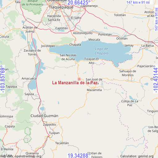
La Manzanilla de la Paz GPS coordinates[2]
20° 0' 17.82" North, 103° 9' 16.416" West
| Map corner | latitude | longitude |
|---|---|---|
| Upper-left | 20.66425°, | -103.85769° |
| Center: | 20.00495°, | -103.15456° |
| Lower-right: | 19.34288°, | -102.45144° |
| Map W x H: | 146.9×146.9 km | = 91.3×91.3mi |
| max Lat: | 32.7° ⇑42.9% North |
| La Manzanilla de la Paz: | 20.00495° |
| min Lat: | ⇓57.1% South 14.53588° |
| min Long | La Manzanilla d | max Long |
| -117.105° | -103.15456° | -86.73105° |
| W 13.6%⇐ | ⇒86.4% E |
Elevation
Elevation of La Manzanilla de la Paz is 2057 m = 6749 ft, and this is 803.3 m = 2635 ft above average elevation for this country.
| Max E: |
3497 m = 11473 ft | 23.5% |
| La Manzanilla de la Paz | 2057 m 6749 ft | |
| Avg. | 1253.7 m = 4113 ft | |
Min E: |
-1 m = -3 ft | 76.5% |
See also: Mexico elevation on elevation.city.
Geographical zone
La Manzanilla de la Paz is located in North Torrid zone (between Equator and Tropic of Cancer). Distance of this Northern Tropic circle is 381.6 km =237.1 mi to North.| Distance of | km | miles | from La Manzanilla de la Paz |
|---|---|---|---|
| North Pole | 7782.7 | 4835.9 | to North |
| Arctic Circle | 5176.8 | 3216.7 | to North |
| Tropic Cancer | 381.6 | 237.1 | to North |
| Equator | 2224.3 | 1382.1 | to South |


Nearby cities:
15 places around La Manzanilla de la Paz: (largest is in red/bold)
• Citala
15.8 km =9.8 mi,  314°
314°
• Concepción de Buenos Aires
11.4 km =7.1 mi,  254°
254°
• El Sabino
22.2 km =13.8 mi,  91°
91°
• El Volantín
7.5 km =4.7 mi,  42°
42°
• Epeche Chico (Penche Chico)
15.9 km =9.9 mi,  117°
117°
• Mazamitla
17.2 km =10.7 mi,  125°
125°
• Mismaloya
17.8 km =11.1 mi,  13°
13°
• Paso de Piedra
21.3 km =13.2 mi,  98°
98°
• San José de Gracia
14 km =8.7 mi, 96°
• Tepeguaje
19.4 km =12.1 mi,  341°
341°
• Tizapán el Alto
20.9 km =13 mi,  33°
33°
• Tuxcueca
16.9 km =10.5 mi,  349°
349°
• Valle de Juárez
23.5 km =14.6 mi,  110°
110°
• Villa Emiliano Zapata
24.8 km =15.4 mi, 43°
• Villa Morelos
5.9 km =3.7 mi, 8°
Sources, notices
• [Note1] Compared only with cities in Mexico existing in our database
• [Src1] Map data: © OpenStreetMap contributors (CC-BY-SA)
• [Src2] Other city data from geonames.org with taken over terms of usage.
• [Src3] Geographical zone / Annual Mean Temperature by Robert A. Rohde @ Wikipedia
