Villa Morelos geodata
Villa Morelos (Jalisco) is a populated place; located in Mexico in America/Mexico_City (GMT-6) time zone. With population of 576 people, there are 14877 cities with bigger population in this country. Compared to other cities in Mexico, 58.2% of cities are located further ↓South; 86.3% of cities are located further →East and 69.6% of cities have lower elevation than Villa Morelos. Note1


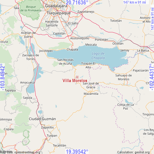
Villa Morelos GPS coordinates[2]
20° 3' 26.208" North, 103° 8' 46.644" West
| Map corner | latitude | longitude |
|---|---|---|
| Upper-left | 20.71636°, | -103.84942° |
| Center: | 20.05728°, | -103.14629° |
| Lower-right: | 19.39542°, | -102.44317° |
| Map W x H: | 146.9×146.9 km | = 91.3×91.3mi |
| max Lat: | 32.7° ⇑41.8% North |
| Villa Morelos: | 20.05728° |
| min Lat: | ⇓58.2% South 14.53588° |
| min Long | Villa Morelos | max Long |
| -117.105° | -103.14629° | -86.73105° |
| W 13.7%⇐ | ⇒86.3% E |
Elevation
Elevation of Villa Morelos is 1918 m = 6293 ft, and this is 664.3 m = 2179 ft above average elevation for this country.
| Max E: |
3497 m = 11473 ft | 30.4% |
| Villa Morelos | 1918 m 6293 ft | |
| Avg. | 1253.7 m = 4113 ft | |
Min E: |
-1 m = -3 ft | 69.6% |
See also: Mexico elevation on elevation.city.
Geographical zone
Villa Morelos is located in North Torrid zone (between Equator and Tropic of Cancer). Distance of this Northern Tropic circle is 375.8 km =233.5 mi to North.| Distance of | km | miles | from Villa Morelos |
|---|---|---|---|
| North Pole | 7776.9 | 4832.3 | to North |
| Arctic Circle | 5171 | 3213.1 | to North |
| Tropic Cancer | 375.8 | 233.5 | to North |
| Equator | 2230.2 | 1385.8 | to South |


Nearby cities:
15 places around Villa Morelos: (largest is in red/bold)
• Citala
13.2 km =8.2 mi,  293°
293°
• Concepción de Buenos Aires
14.8 km =9.2 mi,  233°
233°
• El Sabino
22.2 km =13.8 mi,  106°
106°
• El Volantín
4.2 km =2.6 mi,  93°
93°
• Epeche Chico (Penche Chico)
18.6 km =11.6 mi,  134°
134°
• La Manzanilla de la Paz
5.9 km =3.7 mi,  188°
188°
• Mazamitla
20.5 km =12.7 mi,  140°
140°
• Mismaloya
12 km =7.5 mi,  16°
16°
• Paso de Piedra
22.1 km =13.7 mi, 113°
• San José de Gracia
15 km =9.3 mi,  120°
120°
• San Luis Soyatlán
23 km =14.3 mi,  313°
313°
• Tepeguaje
14.4 km =8.9 mi,  330°
330°
• Tizapán el Alto
15.8 km =9.8 mi,  42°
42°
• Tuxcueca
11.5 km =7.1 mi,  339°
339°
• Villa Emiliano Zapata
20.2 km =12.6 mi,  53°
53°
Sources, notices
• [Note1] Compared only with cities in Mexico existing in our database
• [Src1] Map data: © OpenStreetMap contributors (CC-BY-SA)
• [Src2] Other city data from geonames.org with taken over terms of usage.
• [Src3] Geographical zone / Annual Mean Temperature by Robert A. Rohde @ Wikipedia
