Santa María las Cuevas geodata
Santa María las Cuevas (Tlaxcala) is a populated place; located in Mexico in America/Mexico_City (GMT-6) time zone. With population of 861 people, there are 10161 cities with bigger population in this country. Compared to other cities in Mexico, 56.6% of cities are located further ↑North; 66.8% of cities are located further ←West and 91.1% of cities have lower elevation than Santa María las Cuevas. Note1


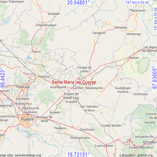
Santa María las Cuevas GPS coordinates[2]
19° 23' 9.996" North, 97° 44' 21.012" West
| Map corner | latitude | longitude |
|---|---|---|
| Upper-left | 20.04801°, | -98.4423° |
| Center: | 19.38611°, | -97.73917° |
| Lower-right: | 18.72151°, | -97.03605° |
| Map W x H: | 147.5×147.5 km | = 91.7×91.7mi |
| max Lat: | 32.7° ⇑56.6% North |
| Santa María las Cuevas: | 19.38611° |
| min Lat: | ⇓43.4% South 14.53588° |
| min Long | Santa María la | max Long |
| -117.105° | -97.73917° | -86.73105° |
| W 66.8%⇐ | ⇒33.2% E |
Elevation
Elevation of Santa María las Cuevas is 2444 m = 8018 ft, and this is 1190.3 m = 3905 ft above average elevation for this country.
| Max E: |
3497 m = 11473 ft | 8.9% |
| Santa María las Cuevas | 2444 m 8018 ft | |
| Avg. | 1253.7 m = 4113 ft | |
Min E: |
-1 m = -3 ft | 91.1% |
See also: Mexico elevation on elevation.city.
Geographical zone
Santa María las Cuevas is located in North Torrid zone (between Equator and Tropic of Cancer). Distance of this Northern Tropic circle is 450.4 km =279.9 mi to North.| Distance of | km | miles | from Santa María las Cuevas |
|---|---|---|---|
| North Pole | 7851.5 | 4878.7 | to North |
| Arctic Circle | 5245.6 | 3259.5 | to North |
| Tropic Cancer | 450.4 | 279.9 | to North |
| Equator | 2155.5 | 1339.4 | to South |


Nearby cities:
15 places around Santa María las Cuevas: (largest is in red/bold)
• Altzayanca
7.8 km =4.8 mi,  310°
310°
• Atlzayanca
7.7 km =4.8 mi, 310°
• Ayehualaco (San Martín)
6.7 km =4.2 mi,  30°
30°
• Colonia Ignacio Allende
5.7 km =3.5 mi,  235°
235°
• Colonia José María Morelos
5 km =3.1 mi,  122°
122°
• Concepción Hidalgo
8.5 km =5.3 mi,  278°
278°
• Guerrero
7.5 km =4.7 mi,  46°
46°
• La Soledad
6 km =3.7 mi, 120°
• Nexnopala
5 km =3.1 mi,  285°
285°
• Plan de Ayala
8.5 km =5.3 mi,  179°
179°
• Ranchería de Pocitos
2.3 km =1.4 mi, 292°
• San Carlos
7.8 km =4.8 mi,  41°
41°
• San Francisco Cuexcontzi
7.9 km =4.9 mi,  157°
157°
• Santa Cruz Pocitos
2.4 km =1.5 mi,  251°
251°
• Xaltitla
5.5 km =3.4 mi,  318°
318°
Sources, notices
• [Note1] Compared only with cities in Mexico existing in our database
• [Src1] Map data: © OpenStreetMap contributors (CC-BY-SA)
• [Src2] Other city data from geonames.org with taken over terms of usage.
• [Src3] Geographical zone / Annual Mean Temperature by Robert A. Rohde @ Wikipedia
