San José el Potrero geodata
San José el Potrero (Guerrero) is a populated place; located in Mexico in America/Mexico_City (GMT-6) time zone. With population of 711 people, there are 12248 cities with bigger population in this country. Compared to other cities in Mexico, 70.8% of cities are located further ↑North; 56.6% of cities are located further →East and 56.8% of cities have higher elevation than San José el Potrero. Note1


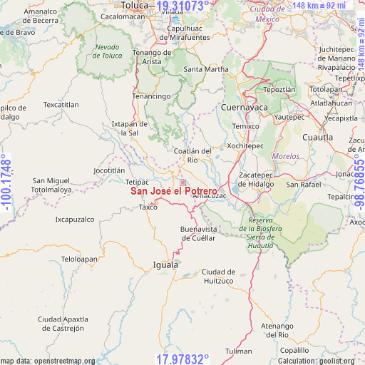
San José el Potrero GPS coordinates[2]
18° 38' 44.988" North, 99° 28' 18.012" West
| Map corner | latitude | longitude |
|---|---|---|
| Upper-left | 19.31073°, | -100.1748° |
| Center: | 18.64583°, | -99.47167° |
| Lower-right: | 17.97832°, | -98.76855° |
| Map W x H: | 148.2×148.2 km | = 92.1×92.1mi |
| max Lat: | 32.7° ⇑70.8% North |
| San José el Potrero: | 18.64583° |
| min Lat: | ⇓29.2% South 14.53588° |
| min Long | San José el Po | max Long |
| -117.105° | -99.47167° | -86.73105° |
| W 43.4%⇐ | ⇒56.6% E |
Elevation
Elevation of San José el Potrero is 1128 m = 3701 ft, and this is 125.7 m = 412 ft below average elevation for this country.
| Max E: |
3497 m = 11473 ft | 56.8% |
| Avg. | 1253.7 m = 4113 ft | |
| San José el Potrero | 1128 m = 3701 ft | |
Min E: |
-1 m = -3 ft | 43.2% |
See also: Mexico elevation on elevation.city.
Geographical zone
San José el Potrero is located in North Torrid zone (between Equator and Tropic of Cancer). Distance of this Northern Tropic circle is 532.7 km =331 mi to North.| Distance of | km | miles | from San José el Potrero |
|---|---|---|---|
| North Pole | 7933.8 | 4929.8 | to North |
| Arctic Circle | 5328 | 3310.7 | to North |
| Tropic Cancer | 532.7 | 331 | to North |
| Equator | 2073.2 | 1288.2 | to South |


Nearby cities:
15 places around San José el Potrero: (largest is in red/bold)
• Acuitlapan
8.9 km =5.5 mi,  236°
236°
• Apancingo
3.9 km =2.4 mi,  12°
12°
• Axixintla
6.9 km =4.3 mi,  225°
225°
• Cacahuamilpa
5.4 km =3.4 mi,  318°
318°
• Chavarría
8.9 km =5.5 mi,  2°
2°
• Chontalcoatlán
10.8 km =6.7 mi,  274°
274°
• Coatlán del Río
11.7 km =7.3 mi,  20°
20°
• Cuauchichinola
10.3 km =6.4 mi,  78°
78°
• El Mogote
10.4 km =6.5 mi,  291°
291°
• Huajintlán
6.4 km =4 mi,  129°
129°
• La Joya
2.4 km =1.5 mi, 12°
• Michapa
6.3 km =3.9 mi,  352°
352°
• Teacalco
3.8 km =2.4 mi,  147°
147°
• Texcaltitla
7.5 km =4.7 mi,  192°
192°
• Tilancingo
10.4 km =6.5 mi, 10°
Sources, notices
• [Note1] Compared only with cities in Mexico existing in our database
• [Src1] Map data: © OpenStreetMap contributors (CC-BY-SA)
• [Src2] Other city data from geonames.org with taken over terms of usage.
• [Src3] Geographical zone / Annual Mean Temperature by Robert A. Rohde @ Wikipedia
