Chontalcoatlán geodata
Chontalcoatlán (Guerrero) is a populated place; located in Mexico in America/Mexico_City (GMT-6) time zone. With population of 1,193 people, there are 7278 cities with bigger population in this country. Compared to other cities in Mexico, 70.7% of cities are located further ↑North; 58% of cities are located further →East and 53.7% of cities have higher elevation than Chontalcoatlán. Note1


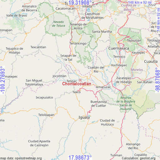
Chontalcoatlán GPS coordinates[2]
18° 39' 15.156" North, 99° 34' 25.68" West
| Map corner | latitude | longitude |
|---|---|---|
| Upper-left | 19.31908°, | -100.27693° |
| Center: | 18.65421°, | -99.5738° |
| Lower-right: | 17.98673°, | -98.87068° |
| Map W x H: | 148.1×148.1 km | = 92×92mi |
| max Lat: | 32.7° ⇑70.7% North |
| Chontalcoatlán: | 18.65421° |
| min Lat: | ⇓29.3% South 14.53588° |
| min Long | Chontalcoatlán | max Long |
| -117.105° | -99.5738° | -86.73105° |
| W 42%⇐ | ⇒58% E |
Elevation
Elevation of Chontalcoatlán is 1259 m = 4131 ft, and this is 5.3 m = 17 ft above average elevation for this country.
| Max E: |
3497 m = 11473 ft | 53.7% |
| Chontalcoatlán | 1259 m 4131 ft | |
| Avg. | 1253.7 m = 4113 ft | |
Min E: |
-1 m = -3 ft | 46.3% |
See also: Mexico elevation on elevation.city.
Geographical zone
Chontalcoatlán is located in North Torrid zone (between Equator and Tropic of Cancer). Distance of this Northern Tropic circle is 531.8 km =330.4 mi to North.| Distance of | km | miles | from Chontalcoatlán |
|---|---|---|---|
| North Pole | 7932.9 | 4929.3 | to North |
| Arctic Circle | 5327 | 3310 | to North |
| Tropic Cancer | 531.8 | 330.4 | to North |
| Equator | 2074.2 | 1288.8 | to South |


Nearby cities:
15 places around Chontalcoatlán: (largest is in red/bold)
• Acamixtla
9.9 km =6.2 mi,  175°
175°
• Acuitlapan
6.7 km =4.2 mi,  150°
150°
• Ahualulco
8 km =5 mi,  275°
275°
• Axixintla
8.2 km =5.1 mi,  134°
134°
• Cacahuamilpa
7.8 km =4.8 mi,  66°
66°
• Colonia las Martelas
10.1 km =6.3 mi,  188°
188°
• El Mogote
3.1 km =1.9 mi,  20°
20°
• Huajojutla (El Azul)
8.4 km =5.2 mi, 179°
• La Joya
11.4 km =7.1 mi,  83°
83°
• Michapa
11.3 km =7 mi,  61°
61°
• San Andrés
4 km =2.5 mi,  259°
259°
• San Gregorio
3.5 km =2.2 mi,  217°
217°
• San José el Potrero
10.8 km =6.7 mi,  94°
94°
• Tenexcontitlán (El Ranchito)
9.8 km =6.1 mi, 282°
• Tetipac
7.8 km =4.8 mi, 264°
Sources, notices
• [Note1] Compared only with cities in Mexico existing in our database
• [Src1] Map data: © OpenStreetMap contributors (CC-BY-SA)
• [Src2] Other city data from geonames.org with taken over terms of usage.
• [Src3] Geographical zone / Annual Mean Temperature by Robert A. Rohde @ Wikipedia
