El Mogote geodata
El Mogote (Guerrero) is a populated place; located in Mexico in America/Mexico_City (GMT-6) time zone. With population of 616 people, there are 13995 cities with bigger population in this country. Compared to other cities in Mexico, 70.5% of cities are located further ↑North; 57.8% of cities are located further →East and 51.3% of cities have lower elevation than El Mogote. Note1


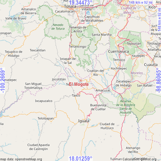
El Mogote GPS coordinates[2]
18° 40' 47.892" North, 99° 33' 49.572" West
| Map corner | latitude | longitude |
|---|---|---|
| Upper-left | 19.34473°, | -100.2669° |
| Center: | 18.67997°, | -99.56377° |
| Lower-right: | 18.01259°, | -98.86065° |
| Map W x H: | 148.1×148.1 km | = 92×92mi |
| max Lat: | 32.7° ⇑70.5% North |
| El Mogote: | 18.67997° |
| min Lat: | ⇓29.5% South 14.53588° |
| min Long | El Mogote | max Long |
| -117.105° | -99.56377° | -86.73105° |
| W 42.2%⇐ | ⇒57.8% E |
Elevation
Elevation of El Mogote is 1499 m = 4918 ft, and this is 245.3 m = 805 ft above average elevation for this country.
| Max E: |
3497 m = 11473 ft | 48.7% |
| El Mogote | 1499 m 4918 ft | |
| Avg. | 1253.7 m = 4113 ft | |
Min E: |
-1 m = -3 ft | 51.3% |
See also: Mexico elevation on elevation.city.
Geographical zone
El Mogote is located in North Torrid zone (between Equator and Tropic of Cancer). Distance of this Northern Tropic circle is 528.9 km =328.6 mi to North.| Distance of | km | miles | from El Mogote |
|---|---|---|---|
| North Pole | 7930 | 4927.5 | to North |
| Arctic Circle | 5324.2 | 3308.3 | to North |
| Tropic Cancer | 528.9 | 328.6 | to North |
| Equator | 2077 | 1290.6 | to South |


Nearby cities:
15 places around El Mogote: (largest is in red/bold)
• Acuitlapan
9 km =5.6 mi,  165°
165°
• Ahualulco
9.2 km =5.7 mi,  257°
257°
• Apancingo
10.6 km =6.6 mi,  90°
90°
• Axixintla
9.9 km =6.2 mi,  150°
150°
• Cacahuamilpa
6.1 km =3.8 mi, 88°
• Chavarría
11.3 km =7 mi,  63°
63°
• Chontalcoatlán
3.1 km =1.9 mi,  200°
200°
• La Joya
10.3 km =6.4 mi,  98°
98°
• Michapa
9.3 km =5.8 mi,  74°
74°
• San Andrés
6.2 km =3.9 mi,  234°
234°
• San Gaspar
11 km =6.8 mi,  8°
8°
• San Gregorio
6.4 km =4 mi,  209°
209°
• San José el Potrero
10.4 km =6.5 mi,  111°
111°
• Tenexcontitlán (El Ranchito)
10.6 km =6.6 mi,  266°
266°
• Tetipac
9.5 km =5.9 mi,  247°
247°
Sources, notices
• [Note1] Compared only with cities in Mexico existing in our database
• [Src1] Map data: © OpenStreetMap contributors (CC-BY-SA)
• [Src2] Other city data from geonames.org with taken over terms of usage.
• [Src3] Geographical zone / Annual Mean Temperature by Robert A. Rohde @ Wikipedia
