Allende geodata
Allende (Chiapas) is a populated place; located in Mexico in America/Mexico_City (GMT-6) time zone. With population of 703 people, there are 12379 cities with bigger population in this country. Compared to other cities in Mexico, 96.7% of cities are located further ↑North; 95.2% of cities are located further ←West and 55% of cities have lower elevation than Allende. Note1


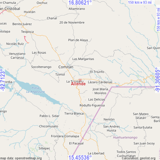
Allende GPS coordinates[2]
16° 7' 54.984" North, 92° 0' 33.012" West
| Map corner | latitude | longitude |
|---|---|---|
| Upper-left | 16.80621°, | -92.7123° |
| Center: | 16.13194°, | -92.00917° |
| Lower-right: | 15.45536°, | -91.30605° |
| Map W x H: | 150.2×150.2 km | = 93.3×93.3mi |
| max Lat: | 32.7° ⇑96.7% North |
| Allende: | 16.13194° |
| min Lat: | ⇓3.3% South 14.53588° |
| min Long | Allende | max Long |
| -117.105° | -92.00917° | -86.73105° |
| W 95.2%⇐ | ⇒4.8% E |
Elevation
Elevation of Allende is 1589 m = 5213 ft, and this is 335.3 m = 1100 ft above average elevation for this country.
| Max E: |
3497 m = 11473 ft | 45% |
| Allende | 1589 m 5213 ft | |
| Avg. | 1253.7 m = 4113 ft | |
Min E: |
-1 m = -3 ft | 55% |
See also: Mexico elevation on elevation.city.
Geographical zone
Allende is located in North Torrid zone (between Equator and Tropic of Cancer). Distance of this Northern Tropic circle is 812.2 km =504.7 mi to North.| Distance of | km | miles | from Allende |
|---|---|---|---|
| North Pole | 8213.4 | 5103.6 | to North |
| Arctic Circle | 5607.5 | 3484.3 | to North |
| Tropic Cancer | 812.2 | 504.7 | to North |
| Equator | 1793.7 | 1114.6 | to South |


Nearby cities:
15 places around Allende: (largest is in red/bold)
• Chentón
8.6 km =5.3 mi,  14°
14°
• Chihuahua
12 km =7.5 mi,  161°
161°
• El Rosario
9.8 km =6.1 mi, 8°
• Emiliano Zapata
7.1 km =4.4 mi,  38°
38°
• Francisco Sarabia
10.6 km =6.6 mi,  286°
286°
• Galeana
10.4 km =6.5 mi,  4°
4°
• Guadalupe Quistaj
9.5 km =5.9 mi,  343°
343°
• Jatón Chacaljemel
11.9 km =7.4 mi,  302°
302°
• La Trinitaria
4.8 km =3 mi,  252°
252°
• Michoacán
6.1 km =3.8 mi, 288°
• Quistajito
11.1 km =6.9 mi,  359°
359°
• San Diego
5.5 km =3.4 mi,  112°
112°
• Santa Rita
3.6 km =2.2 mi,  90°
90°
• Unión Juárez
8.1 km =5 mi, 92°
• Venustiano Carranza
10.9 km =6.8 mi,  53°
53°
Sources, notices
• [Note1] Compared only with cities in Mexico existing in our database
• [Src1] Map data: © OpenStreetMap contributors (CC-BY-SA)
• [Src2] Other city data from geonames.org with taken over terms of usage.
• [Src3] Geographical zone / Annual Mean Temperature by Robert A. Rohde @ Wikipedia
