Jatón Chacaljemel geodata
Jatón Chacaljemel (Chiapas) is a populated place; located in Mexico in America/Mexico_City (GMT-6) time zone. With population of 584 people, there are 14684 cities with bigger population in this country. Compared to other cities in Mexico, 96.4% of cities are located further ↑North; 94.8% of cities are located further ←West and 54.8% of cities have lower elevation than Jatón Chacaljemel. Note1


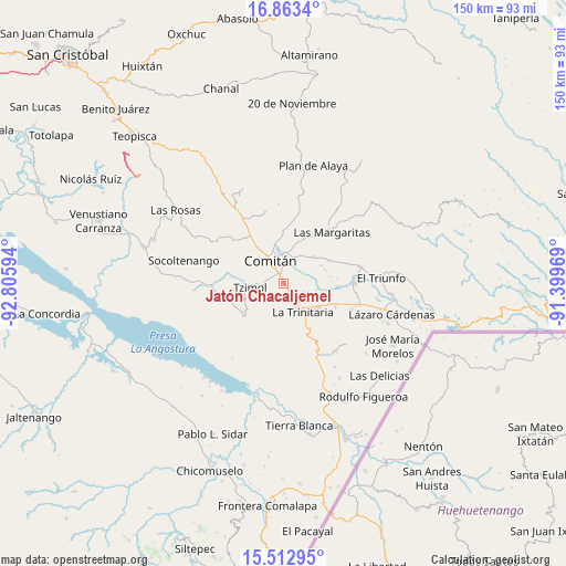
Jatón Chacaljemel GPS coordinates[2]
16° 11' 21.588" North, 92° 6' 10.116" West
| Map corner | latitude | longitude |
|---|---|---|
| Upper-left | 16.8634°, | -92.80594° |
| Center: | 16.18933°, | -92.10281° |
| Lower-right: | 15.51295°, | -91.39969° |
| Map W x H: | 150.2×150.2 km | = 93.3×93.3mi |
| max Lat: | 32.7° ⇑96.4% North |
| Jatón Chacaljemel: | 16.18933° |
| min Lat: | ⇓3.6% South 14.53588° |
| min Long | Jatón Chacalje | max Long |
| -117.105° | -92.10281° | -86.73105° |
| W 94.8%⇐ | ⇒5.2% E |
Elevation
Elevation of Jatón Chacaljemel is 1584 m = 5197 ft, and this is 330.3 m = 1084 ft above average elevation for this country.
| Max E: |
3497 m = 11473 ft | 45.2% |
| Jatón Chacaljemel | 1584 m 5197 ft | |
| Avg. | 1253.7 m = 4113 ft | |
Min E: |
-1 m = -3 ft | 54.8% |
See also: Mexico elevation on elevation.city.
Geographical zone
Jatón Chacaljemel is located in North Torrid zone (between Equator and Tropic of Cancer). Distance of this Northern Tropic circle is 805.8 km =500.7 mi to North.| Distance of | km | miles | from Jatón Chacaljemel |
|---|---|---|---|
| North Pole | 8207 | 5099.6 | to North |
| Arctic Circle | 5601.1 | 3480.4 | to North |
| Tropic Cancer | 805.8 | 500.7 | to North |
| Equator | 1800.1 | 1118.5 | to South |


Nearby cities:
15 places around Jatón Chacaljemel: (largest is in red/bold)
• Cajcam
10.3 km =6.4 mi,  33°
33°
• Cash
8.3 km =5.2 mi,  3°
3°
• Comitán
7.3 km =4.5 mi,  331°
331°
• Francisco Sarabia
3.4 km =2.1 mi,  183°
183°
• Guadalupe Quistaj
7.8 km =4.8 mi,  69°
69°
• La Independencia
11 km =6.8 mi,  50°
50°
• La Trinitaria
9.6 km =6 mi,  145°
145°
• Michoacán
6.1 km =3.8 mi,  136°
136°
• Quija
10.4 km =6.5 mi, 333°
• Quistajito
11 km =6.8 mi,  64°
64°
• Río Grande
10.3 km =6.4 mi,  347°
347°
• San Francisco el Rincón
10.7 km =6.6 mi,  342°
342°
• San José Yocnajab
7.4 km =4.6 mi,  13°
13°
• San Miguel Tinajab
10.3 km =6.4 mi,  359°
359°
• Tzimol
9.3 km =5.8 mi,  266°
266°
Sources, notices
• [Note1] Compared only with cities in Mexico existing in our database
• [Src1] Map data: © OpenStreetMap contributors (CC-BY-SA)
• [Src2] Other city data from geonames.org with taken over terms of usage.
• [Src3] Geographical zone / Annual Mean Temperature by Robert A. Rohde @ Wikipedia
