Chentón geodata
Chentón (Chiapas) is a populated place; located in Mexico in America/Mexico_City (GMT-6) time zone. With population of 512 people, there are 16417 cities with bigger population in this country. Compared to other cities in Mexico, 96.3% of cities are located further ↑North; 95.3% of cities are located further ←West and 52.4% of cities have lower elevation than Chentón. Note1


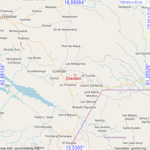
Chentón GPS coordinates[2]
16° 12' 24.588" North, 91° 59' 18.276" West
| Map corner | latitude | longitude |
|---|---|---|
| Upper-left | 16.88084°, | -92.69154° |
| Center: | 16.20683°, | -91.98841° |
| Lower-right: | 15.5305°, | -91.28529° |
| Map W x H: | 150.1×150.1 km | = 93.3×93.3mi |
| max Lat: | 32.7° ⇑96.3% North |
| Chentón: | 16.20683° |
| min Lat: | ⇓3.7% South 14.53588° |
| min Long | Chentón | max Long |
| -117.105° | -91.98841° | -86.73105° |
| W 95.3%⇐ | ⇒4.7% E |
Elevation
Elevation of Chentón is 1531 m = 5023 ft, and this is 277.3 m = 910 ft above average elevation for this country.
| Max E: |
3497 m = 11473 ft | 47.6% |
| Chentón | 1531 m 5023 ft | |
| Avg. | 1253.7 m = 4113 ft | |
Min E: |
-1 m = -3 ft | 52.4% |
See also: Mexico elevation on elevation.city.
Geographical zone
Chentón is located in North Torrid zone (between Equator and Tropic of Cancer). Distance of this Northern Tropic circle is 803.9 km =499.5 mi to North.| Distance of | km | miles | from Chentón |
|---|---|---|---|
| North Pole | 8205 | 5098.3 | to North |
| Arctic Circle | 5599.1 | 3479.1 | to North |
| Tropic Cancer | 803.9 | 499.5 | to North |
| Equator | 1802 | 1119.7 | to South |


Nearby cities:
15 places around Chentón: (largest is in red/bold)
• Allende
8.6 km =5.3 mi,  194°
194°
• Buenavista
4 km =2.5 mi,  0°
0°
• Cajcam
9.4 km =5.8 mi,  315°
315°
• El Rosario
1.6 km =1 mi,  330°
330°
• Emiliano Zapata
3.5 km =2.2 mi,  141°
141°
• Francisco Sarabia
5.3 km =3.3 mi,  31°
31°
• Galeana
2.4 km =1.5 mi, 327°
• Guadalupe Quistaj
4.9 km =3 mi,  279°
279°
• La Independencia
6.3 km =3.9 mi, 323°
• La Patria
8.6 km =5.3 mi,  72°
72°
• Primero de Mayo
9.7 km =6 mi, 332°
• Quistajito
3.6 km =2.2 mi, 320°
• San Antonio Chiquinivaltic
7.9 km =4.9 mi,  61°
61°
• Santa Rita
8.5 km =5.3 mi,  170°
170°
• Venustiano Carranza
6.8 km =4.2 mi,  105°
105°
Sources, notices
• [Note1] Compared only with cities in Mexico existing in our database
• [Src1] Map data: © OpenStreetMap contributors (CC-BY-SA)
• [Src2] Other city data from geonames.org with taken over terms of usage.
• [Src3] Geographical zone / Annual Mean Temperature by Robert A. Rohde @ Wikipedia
