Emiliano Zapata geodata
Emiliano Zapata (Chiapas) is a populated place; located in Mexico in America/Mexico_City (GMT-6) time zone. With population of 1,234 people, there are 7034 cities with bigger population in this country. Compared to other cities in Mexico, 96.4% of cities are located further ↑North; 95.4% of cities are located further ←West and 51.6% of cities have lower elevation than Emiliano Zapata. Note1


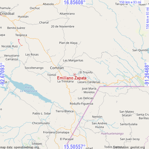
Emiliano Zapata GPS coordinates[2]
16° 10' 55.128" North, 91° 58' 4.08" West
| Map corner | latitude | longitude |
|---|---|---|
| Upper-left | 16.85608°, | -92.67093° |
| Center: | 16.18198°, | -91.9678° |
| Lower-right: | 15.50557°, | -91.26468° |
| Map W x H: | 150.2×150.2 km | = 93.3×93.3mi |
| max Lat: | 32.7° ⇑96.4% North |
| Emiliano Zapata: | 16.18198° |
| min Lat: | ⇓3.6% South 14.53588° |
| min Long | Emiliano Zapata | max Long |
| -117.105° | -91.9678° | -86.73105° |
| W 95.4%⇐ | ⇒4.6% E |
Elevation
Elevation of Emiliano Zapata is 1511 m = 4957 ft, and this is 257.3 m = 844 ft above average elevation for this country.
| Max E: |
3497 m = 11473 ft | 48.4% |
| Emiliano Zapata | 1511 m 4957 ft | |
| Avg. | 1253.7 m = 4113 ft | |
Min E: |
-1 m = -3 ft | 51.6% |
See also: Mexico elevation on elevation.city.
Geographical zone
Emiliano Zapata is located in North Torrid zone (between Equator and Tropic of Cancer). Distance of this Northern Tropic circle is 806.7 km =501.3 mi to North.| Distance of | km | miles | from Emiliano Zapata |
|---|---|---|---|
| North Pole | 8207.8 | 5100.1 | to North |
| Arctic Circle | 5601.9 | 3480.9 | to North |
| Tropic Cancer | 806.7 | 501.3 | to North |
| Equator | 1799.3 | 1118 | to South |


Nearby cities:
15 places around Emiliano Zapata: (largest is in red/bold)
• Allende
7.1 km =4.4 mi,  218°
218°
• Buenavista
7.1 km =4.4 mi,  342°
342°
• Chentón
3.5 km =2.2 mi,  321°
321°
• El Rosario
5.1 km =3.2 mi, 324°
• Francisco Sarabia
7.3 km =4.5 mi,  4°
4°
• Galeana
6 km =3.7 mi, 323°
• Guadalupe Quistaj
7.9 km =4.9 mi,  296°
296°
• La Independencia
9.9 km =6.2 mi, 322°
• La Patria
8 km =5 mi,  48°
48°
• Quistajito
7.2 km =4.5 mi, 321°
• San Antonio Chiquinivaltic
8 km =5 mi,  36°
36°
• San Diego
7.7 km =4.8 mi,  175°
175°
• Santa Rita
5.6 km =3.5 mi,  187°
187°
• Unión Juárez
7 km =4.3 mi,  148°
148°
• Venustiano Carranza
4.4 km =2.7 mi,  78°
78°
Sources, notices
• [Note1] Compared only with cities in Mexico existing in our database
• [Src1] Map data: © OpenStreetMap contributors (CC-BY-SA)
• [Src2] Other city data from geonames.org with taken over terms of usage.
• [Src3] Geographical zone / Annual Mean Temperature by Robert A. Rohde @ Wikipedia
