Benito Juárez geodata
Benito Juárez (Veracruz) is a populated place; located in Mexico in America/Mexico_City (GMT-6) time zone. With population of 702 people, there are 12396 cities with bigger population in this country. Compared to other cities in Mexico, 75.2% of cities are located further ↑North; 82.5% of cities are located further ←West and 93% of cities have higher elevation than Benito Juárez. Note1


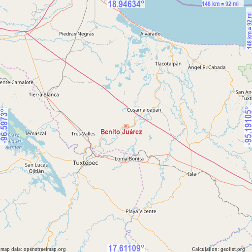
Benito Juárez GPS coordinates[2]
18° 16' 48" North, 95° 53' 39.012" West
| Map corner | latitude | longitude |
|---|---|---|
| Upper-left | 18.94634°, | -96.5973° |
| Center: | 18.28°, | -95.89417° |
| Lower-right: | 17.61109°, | -95.19105° |
| Map W x H: | 148.5×148.5 km | = 92.3×92.3mi |
| max Lat: | 32.7° ⇑75.2% North |
| Benito Juárez: | 18.28° |
| min Lat: | ⇓24.8% South 14.53588° |
| min Long | Benito Juárez | max Long |
| -117.105° | -95.89417° | -86.73105° |
| W 82.5%⇐ | ⇒17.5% E |
Elevation
Elevation of Benito Juárez is 17 m = 56 ft, and this is 1236.7 m = 4057 ft below average elevation for this country.
| Max E: |
3497 m = 11473 ft | 93% |
| Avg. | 1253.7 m = 4113 ft | |
| Benito Juárez | 17 m = 56 ft | |
Min E: |
-1 m = -3 ft | 7% |
See also: Mexico elevation on elevation.city.
Geographical zone
Benito Juárez is located in North Torrid zone (between Equator and Tropic of Cancer). Distance of this Northern Tropic circle is 573.4 km =356.3 mi to North.| Distance of | km | miles | from Benito Juárez |
|---|---|---|---|
| North Pole | 7974.5 | 4955.1 | to North |
| Arctic Circle | 5368.6 | 3335.9 | to North |
| Tropic Cancer | 573.4 | 356.3 | to North |
| Equator | 2032.5 | 1262.9 | to South |


Nearby cities:
15 places around Benito Juárez: (largest is in red/bold)
• Arroyo del Soldado (Arroyo del Obispo)
12.8 km =8 mi,  71°
71°
• Cerro Colorado
4.8 km =3 mi,  76°
76°
• Chacaltianguis
6.2 km =3.9 mi,  63°
63°
• Chicalpextle
13.9 km =8.6 mi,  28°
28°
• Cosamaloapan
14 km =8.7 mi,  46°
46°
• El Mirador
9.9 km =6.2 mi,  359°
359°
• Fernando López Arias
8.8 km =5.5 mi,  327°
327°
• Los Bálsamos
7.4 km =4.6 mi,  350°
350°
• Mata de Caña
9.4 km =5.8 mi,  140°
140°
• Nopaltepec
11.1 km =6.9 mi,  268°
268°
• Paraiso Novillero
5.4 km =3.4 mi,  235°
235°
• San Francisco (Oyozontle)
7.5 km =4.7 mi,  42°
42°
• San Isidro
10 km =6.2 mi,  255°
255°
• Tlacojalpan
7.8 km =4.8 mi,  225°
225°
• Tuxtilla
4.6 km =2.9 mi,  180°
180°
Sources, notices
• [Note1] Compared only with cities in Mexico existing in our database
• [Src1] Map data: © OpenStreetMap contributors (CC-BY-SA)
• [Src2] Other city data from geonames.org with taken over terms of usage.
• [Src3] Geographical zone / Annual Mean Temperature by Robert A. Rohde @ Wikipedia
