Mata de Caña geodata
Mata de Caña (Veracruz) is a populated place; located in Mexico in America/Mexico_City (GMT-6) time zone. With population of 585 people, there are 14661 cities with bigger population in this country. Compared to other cities in Mexico, 76% of cities are located further ↑North; 82.6% of cities are located further ←West and 91.6% of cities have higher elevation than Mata de Caña. Note1


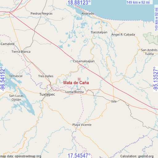
Mata de Caña GPS coordinates[2]
18° 12' 52.668" North, 95° 50' 18.204" West
| Map corner | latitude | longitude |
|---|---|---|
| Upper-left | 18.88123°, | -96.54152° |
| Center: | 18.21463°, | -95.83839° |
| Lower-right: | 17.54547°, | -95.13527° |
| Map W x H: | 148.5×148.5 km | = 92.3×92.3mi |
| max Lat: | 32.7° ⇑76% North |
| Mata de Caña: | 18.21463° |
| min Lat: | ⇓24% South 14.53588° |
| min Long | Mata de Caña | max Long |
| -117.105° | -95.83839° | -86.73105° |
| W 82.6%⇐ | ⇒17.4% E |
Elevation
Elevation of Mata de Caña is 20 m = 66 ft, and this is 1233.7 m = 4048 ft below average elevation for this country.
| Max E: |
3497 m = 11473 ft | 91.6% |
| Avg. | 1253.7 m = 4113 ft | |
| Mata de Caña | 20 m = 66 ft | |
Min E: |
-1 m = -3 ft | 8.4% |
See also: Mexico elevation on elevation.city.
Geographical zone
Mata de Caña is located in North Torrid zone (between Equator and Tropic of Cancer). Distance of this Northern Tropic circle is 580.6 km =360.8 mi to North.| Distance of | km | miles | from Mata de Caña |
|---|---|---|---|
| North Pole | 7981.8 | 4959.7 | to North |
| Arctic Circle | 5375.9 | 3340.4 | to North |
| Tropic Cancer | 580.6 | 360.8 | to North |
| Equator | 2025.3 | 1258.5 | to South |


Nearby cities:
15 places around Mata de Caña: (largest is in red/bold)
• Arroyo del Soldado (Arroyo del Obispo)
12.9 km =8 mi,  29°
29°
• Benito Juárez
9.4 km =5.8 mi,  320°
320°
• Cerro Colorado
8.5 km =5.3 mi,  351°
351°
• Chacaltianguis
10.1 km =6.3 mi,  358°
358°
• Estación Dobladero
13.5 km =8.4 mi,  145°
145°
• Las Mesas
12.5 km =7.8 mi,  99°
99°
• Las Sabanetas
9.9 km =6.2 mi,  170°
170°
• Lindavista
15.4 km =9.6 mi, 154°
• Loma Bonita
12.7 km =7.9 mi,  199°
199°
• Paraiso Novillero
11.2 km =7 mi,  292°
292°
• San Francisco (Oyozontle)
12.8 km =8 mi, 356°
• Tilapa
13.8 km =8.6 mi,  37°
37°
• Tlacojalpan
11.6 km =7.2 mi,  279°
279°
• Tuxtilla
6.5 km =4 mi, 294°
• Vicente Guerrero (El Aguacate)
16 km =9.9 mi,  85°
85°
Sources, notices
• [Note1] Compared only with cities in Mexico existing in our database
• [Src1] Map data: © OpenStreetMap contributors (CC-BY-SA)
• [Src2] Other city data from geonames.org with taken over terms of usage.
• [Src3] Geographical zone / Annual Mean Temperature by Robert A. Rohde @ Wikipedia
